You are here: Home > Network List > RV - Regional Alberta Seismic Observatory for Earthquake Studies Network Stations List
> Station LGPLA Lodgepole, Alberta > Earthquake Result Viewer
LGPLA Lodgepole, Alberta - Earthquake Result Viewer
| Earthquake location: |
Near Coast Of Ecuador |
| Earthquake latitude/longitude: |
0.6/-79.6 |
| Earthquake time(UTC): |
2016/07/11 (193) 02:01:09 GMT |
| Earthquake Depth: |
14 km |
| Earthquake Magnitude: |
5.8 MWW, 5.7 MWB, 5.9 MWC |
| Earthquake Catalog/Contributor: |
NEIC PDE/NEIC COMCAT |
|
| Network: |
RV Regional Alberta Seismic Observatory for Earthquake Studies Network |
| Station: |
LGPLA Lodgepole, Alberta |
| Lat/Lon: |
53.12 N/115.36 W |
| Elevation: |
877 m |
|
| Distance: |
60.2 deg |
| Az: |
336.076 deg |
| Baz: |
137.72 deg |
| Ray Param: |
0.06169615 |
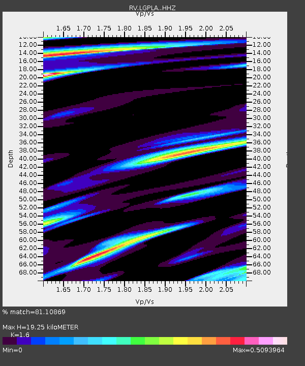
| Estimated Moho Depth: |
19.25 km |
| Estimated Crust Vp/Vs: |
1.60 |
| Assumed Crust Vp: |
6.426 km/s |
| Estimated Crust Vs: |
4.016 km/s |
| Estimated Crust Poisson's Ratio: |
0.18 |
|
| Radial Match: |
81.10869 % |
| Radial Bump: |
396 |
| Transverse Match: |
59.35967 % |
| Transverse Bump: |
400 |
| SOD ConfigId: |
11737051 |
| Insert Time: |
2019-04-25 01:27:05.190 +0000 |
| GWidth: |
2.5 |
| Max Bumps: |
400 |
| Tol: |
0.001 |
|

Signal To Noise
| Channel | StoN | STA | LTA |
| RV:LGPLA: :HHZ:20160711T02:10:45.570005Z | 10.231732 | 8.322514E-7 | 8.1340225E-8 |
| RV:LGPLA: :HHN:20160711T02:10:45.570005Z | 3.027864 | 2.4844138E-7 | 8.20517E-8 |
| RV:LGPLA: :HHE:20160711T02:10:45.570005Z | 3.7875955 | 3.7130658E-7 | 9.803227E-8 |
| Arrivals |
| Ps | 1.9 SECOND |
| PpPs | 7.4 SECOND |
| PsPs/PpSs | 9.3 SECOND |


