You are here: Home > Network List > TA - USArray Transportable Network (new EarthScope stations) Stations List
> Station C23K Itkillik River, AK, USA > Earthquake Result Viewer
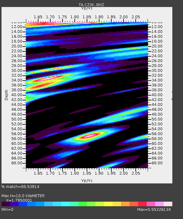
C23K Itkillik River, AK, USA - Earthquake Result Viewer
| Earthquake location: |
Near Coast Of Ecuador |
| Earthquake latitude/longitude: |
0.6/-79.6 |
| Earthquake time(UTC): |
2016/07/11 (193) 02:01:09 GMT |
| Earthquake Depth: |
14 km |
| Earthquake Magnitude: |
5.8 MWW, 5.7 MWB, 5.9 MWC |
| Earthquake Catalog/Contributor: |
NEIC PDE/NEIC COMCAT |
|
| Network: |
TA USArray Transportable Network (new EarthScope stations) |
| Station: |
C23K Itkillik River, AK, USA |
| Lat/Lon: |
69.84 N/150.61 W |
| Elevation: |
179 m |
|
| Distance: |
83.0 deg |
| Az: |
340.714 deg |
| Baz: |
107.741 deg |
| Ray Param: |
0.046510357 |
| Estimated Moho Depth: |
10.0 km |
| Estimated Crust Vp/Vs: |
1.80 |
| Assumed Crust Vp: |
6.221 km/s |
| Estimated Crust Vs: |
3.466 km/s |
| Estimated Crust Poisson's Ratio: |
0.27 |
|
| Radial Match: |
88.53914 % |
| Radial Bump: |
399 |
| Transverse Match: |
91.008316 % |
| Transverse Bump: |
391 |
| SOD ConfigId: |
11737051 |
| Insert Time: |
2019-04-25 01:27:23.152 +0000 |
| GWidth: |
2.5 |
| Max Bumps: |
400 |
| Tol: |
0.001 |
|

Signal To Noise
| Channel | StoN | STA | LTA |
| TA:C23K: :BHZ:20160711T02:13:02.474973Z | 10.251704 | 7.7235234E-7 | 7.5338924E-8 |
| TA:C23K: :BHN:20160711T02:13:02.474973Z | 3.578861 | 2.3017313E-7 | 6.4314634E-8 |
| TA:C23K: :BHE:20160711T02:13:02.474973Z | 1.6777475 | 1.11838276E-7 | 6.665978E-8 |
| Arrivals |
| Ps | 1.3 SECOND |
| PpPs | 4.4 SECOND |
| PsPs/PpSs | 5.7 SECOND |


