You are here: Home > Network List > TA - USArray Transportable Network (new EarthScope stations) Stations List
> Station E24K Your Creek, AK, USA > Earthquake Result Viewer
E24K Your Creek, AK, USA - Earthquake Result Viewer
| Earthquake location: |
Near Coast Of Ecuador |
| Earthquake latitude/longitude: |
0.6/-79.6 |
| Earthquake time(UTC): |
2016/07/11 (193) 02:01:09 GMT |
| Earthquake Depth: |
14 km |
| Earthquake Magnitude: |
5.8 MWW, 5.7 MWB, 5.9 MWC |
| Earthquake Catalog/Contributor: |
NEIC PDE/NEIC COMCAT |
|
| Network: |
TA USArray Transportable Network (new EarthScope stations) |
| Station: |
E24K Your Creek, AK, USA |
| Lat/Lon: |
68.07 N/148.49 W |
| Elevation: |
847 m |
|
| Distance: |
81.7 deg |
| Az: |
339.27 deg |
| Baz: |
109.53 deg |
| Ray Param: |
0.047411267 |
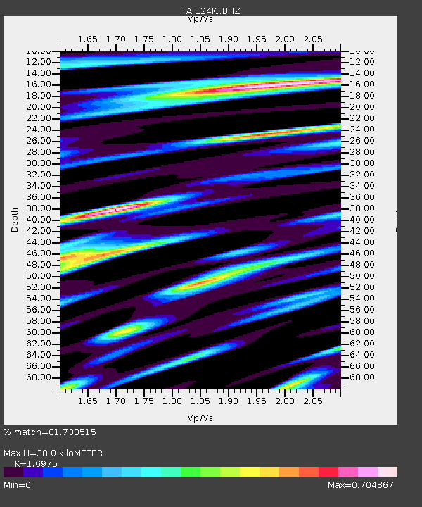
| Estimated Moho Depth: |
38.0 km |
| Estimated Crust Vp/Vs: |
1.70 |
| Assumed Crust Vp: |
6.316 km/s |
| Estimated Crust Vs: |
3.721 km/s |
| Estimated Crust Poisson's Ratio: |
0.23 |
|
| Radial Match: |
81.730515 % |
| Radial Bump: |
400 |
| Transverse Match: |
80.08586 % |
| Transverse Bump: |
400 |
| SOD ConfigId: |
11737051 |
| Insert Time: |
2019-04-25 01:27:28.223 +0000 |
| GWidth: |
2.5 |
| Max Bumps: |
400 |
| Tol: |
0.001 |
|

Signal To Noise
| Channel | StoN | STA | LTA |
| TA:E24K: :BHZ:20160711T02:12:55.749998Z | 11.573157 | 4.0392337E-7 | 3.4901742E-8 |
| TA:E24K: :BHN:20160711T02:12:55.749998Z | 1.0235765 | 3.0037732E-8 | 2.9345863E-8 |
| TA:E24K: :BHE:20160711T02:12:55.749998Z | 4.3114676 | 1.2082464E-7 | 2.8024017E-8 |
| Arrivals |
| Ps | 4.3 SECOND |
| PpPs | 16 SECOND |
| PsPs/PpSs | 20 SECOND |


