You are here: Home > Network List > TA - USArray Transportable Network (new EarthScope stations) Stations List
> Station H23K Yukon River, AK, USA > Earthquake Result Viewer
H23K Yukon River, AK, USA - Earthquake Result Viewer
| Earthquake location: |
Near Coast Of Ecuador |
| Earthquake latitude/longitude: |
0.6/-79.6 |
| Earthquake time(UTC): |
2016/07/11 (193) 02:01:09 GMT |
| Earthquake Depth: |
14 km |
| Earthquake Magnitude: |
5.8 MWW, 5.7 MWB, 5.9 MWC |
| Earthquake Catalog/Contributor: |
NEIC PDE/NEIC COMCAT |
|
| Network: |
TA USArray Transportable Network (new EarthScope stations) |
| Station: |
H23K Yukon River, AK, USA |
| Lat/Lon: |
65.83 N/149.54 W |
| Elevation: |
617 m |
|
| Distance: |
81.3 deg |
| Az: |
336.971 deg |
| Baz: |
108.22 deg |
| Ray Param: |
0.047648452 |
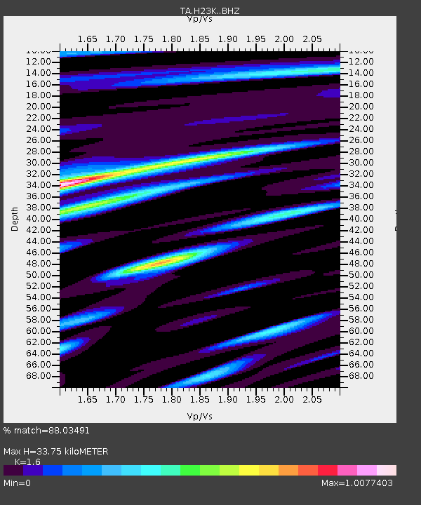
| Estimated Moho Depth: |
33.75 km |
| Estimated Crust Vp/Vs: |
1.60 |
| Assumed Crust Vp: |
6.566 km/s |
| Estimated Crust Vs: |
4.104 km/s |
| Estimated Crust Poisson's Ratio: |
0.18 |
|
| Radial Match: |
88.03491 % |
| Radial Bump: |
400 |
| Transverse Match: |
81.44622 % |
| Transverse Bump: |
400 |
| SOD ConfigId: |
11737051 |
| Insert Time: |
2019-04-25 01:27:36.605 +0000 |
| GWidth: |
2.5 |
| Max Bumps: |
400 |
| Tol: |
0.001 |
|

Signal To Noise
| Channel | StoN | STA | LTA |
| TA:H23K: :BHZ:20160711T02:12:53.95001Z | 9.203392 | 3.581916E-7 | 3.891952E-8 |
| TA:H23K: :BHN:20160711T02:12:53.95001Z | 3.1884882 | 1.2443579E-7 | 3.902658E-8 |
| TA:H23K: :BHE:20160711T02:12:53.95001Z | 2.9828584 | 1.459535E-7 | 4.893075E-8 |
| Arrivals |
| Ps | 3.2 SECOND |
| PpPs | 13 SECOND |
| PsPs/PpSs | 16 SECOND |


