You are here: Home > Network List > TA - USArray Transportable Network (new EarthScope stations) Stations List
> Station M31M Drury Creek, Yukon, CA > Earthquake Result Viewer
M31M Drury Creek, Yukon, CA - Earthquake Result Viewer
| Earthquake location: |
Near Coast Of Ecuador |
| Earthquake latitude/longitude: |
0.6/-79.6 |
| Earthquake time(UTC): |
2016/07/11 (193) 02:01:09 GMT |
| Earthquake Depth: |
14 km |
| Earthquake Magnitude: |
5.8 MWW, 5.7 MWB, 5.9 MWC |
| Earthquake Catalog/Contributor: |
NEIC PDE/NEIC COMCAT |
|
| Network: |
TA USArray Transportable Network (new EarthScope stations) |
| Station: |
M31M Drury Creek, Yukon, CA |
| Lat/Lon: |
62.20 N/134.39 W |
| Elevation: |
639 m |
|
| Distance: |
73.8 deg |
| Az: |
336.503 deg |
| Baz: |
121.744 deg |
| Ray Param: |
0.052769158 |
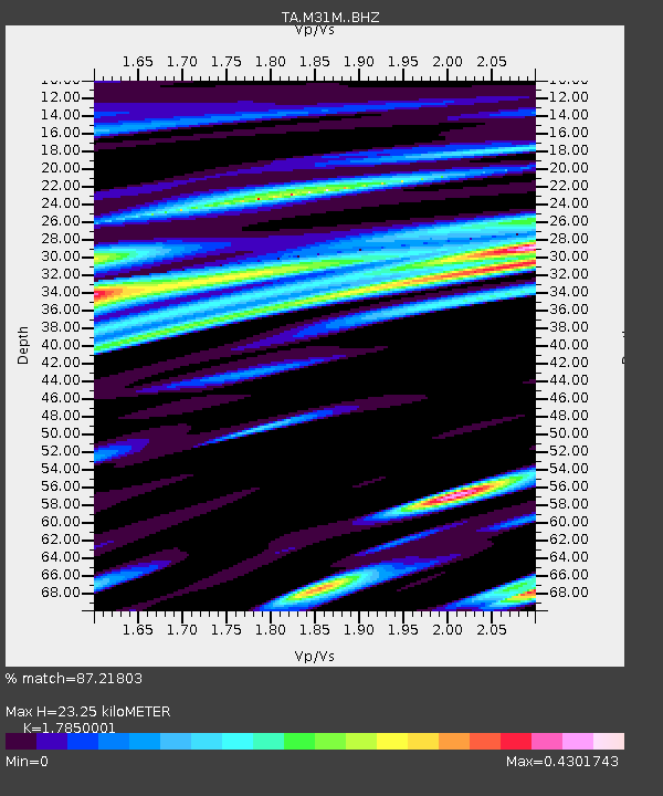
| Estimated Moho Depth: |
23.25 km |
| Estimated Crust Vp/Vs: |
1.79 |
| Assumed Crust Vp: |
6.419 km/s |
| Estimated Crust Vs: |
3.596 km/s |
| Estimated Crust Poisson's Ratio: |
0.27 |
|
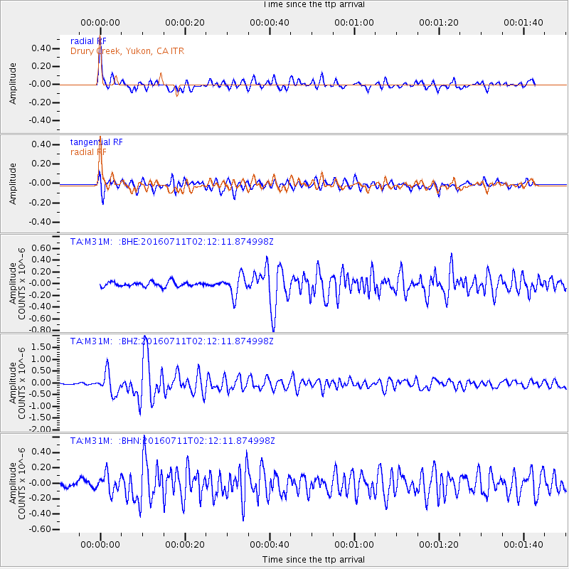
| Radial Match: |
87.21803 % |
| Radial Bump: |
400 |
| Transverse Match: |
77.57107 % |
| Transverse Bump: |
400 |
| SOD ConfigId: |
11737051 |
| Insert Time: |
2019-04-25 01:28:01.066 +0000 |
| GWidth: |
2.5 |
| Max Bumps: |
400 |
| Tol: |
0.001 |
|
Signal To Noise
| Channel | StoN | STA | LTA |
| TA:M31M: :BHZ:20160711T02:12:11.874998Z | 9.523444 | 4.6108735E-7 | 4.841603E-8 |
| TA:M31M: :BHN:20160711T02:12:11.874998Z | 2.5474167 | 1.1821817E-7 | 4.6407077E-8 |
| TA:M31M: :BHE:20160711T02:12:11.874998Z | 4.483283 | 1.7913779E-7 | 3.995683E-8 |
| Arrivals |
| Ps | 2.9 SECOND |
| PpPs | 9.8 SECOND |
| PsPs/PpSs | 13 SECOND |


