You are here: Home > Network List > TA - USArray Transportable Network (new EarthScope stations) Stations List
> Station N19K Bonanza Creek NPS repeater, AK, USA > Earthquake Result Viewer
N19K Bonanza Creek NPS repeater, AK, USA - Earthquake Result Viewer
| Earthquake location: |
Near Coast Of Ecuador |
| Earthquake latitude/longitude: |
0.6/-79.6 |
| Earthquake time(UTC): |
2016/07/11 (193) 02:01:09 GMT |
| Earthquake Depth: |
14 km |
| Earthquake Magnitude: |
5.8 MWW, 5.7 MWB, 5.9 MWC |
| Earthquake Catalog/Contributor: |
NEIC PDE/NEIC COMCAT |
|
| Network: |
TA USArray Transportable Network (new EarthScope stations) |
| Station: |
N19K Bonanza Creek NPS repeater, AK, USA |
| Lat/Lon: |
60.81 N/154.48 W |
| Elevation: |
1144 m |
|
| Distance: |
82.1 deg |
| Az: |
331.472 deg |
| Baz: |
103.015 deg |
| Ray Param: |
0.047090266 |
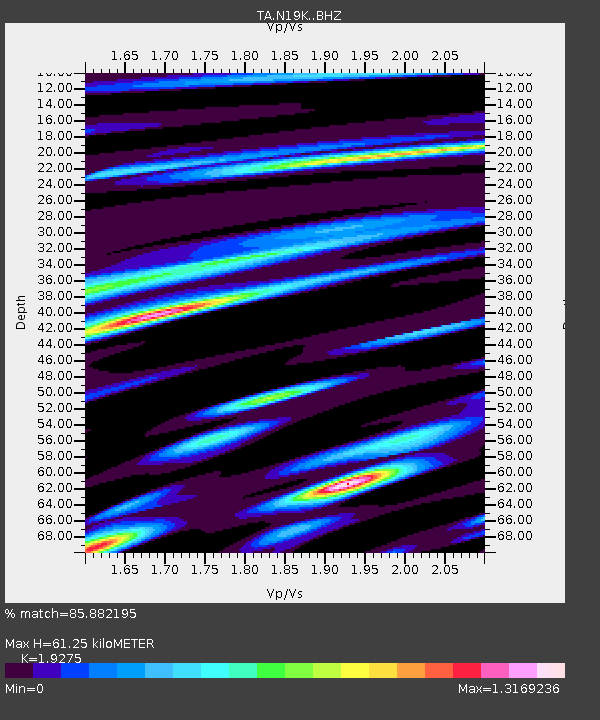
| Estimated Moho Depth: |
61.25 km |
| Estimated Crust Vp/Vs: |
1.93 |
| Assumed Crust Vp: |
6.566 km/s |
| Estimated Crust Vs: |
3.407 km/s |
| Estimated Crust Poisson's Ratio: |
0.32 |
|
| Radial Match: |
85.882195 % |
| Radial Bump: |
400 |
| Transverse Match: |
64.47944 % |
| Transverse Bump: |
400 |
| SOD ConfigId: |
11737051 |
| Insert Time: |
2019-04-25 01:28:05.669 +0000 |
| GWidth: |
2.5 |
| Max Bumps: |
400 |
| Tol: |
0.001 |
|

Signal To Noise
| Channel | StoN | STA | LTA |
| TA:N19K: :BHZ:20160711T02:12:58.150022Z | 4.7699847 | 3.3425056E-7 | 7.007372E-8 |
| TA:N19K: :BHN:20160711T02:12:58.150022Z | 1.8380458 | 9.830256E-8 | 5.3482104E-8 |
| TA:N19K: :BHE:20160711T02:12:58.150022Z | 2.7244883 | 1.518205E-7 | 5.5724414E-8 |
| Arrivals |
| Ps | 8.9 SECOND |
| PpPs | 27 SECOND |
| PsPs/PpSs | 35 SECOND |


