You are here: Home > Network List > TA - USArray Transportable Network (new EarthScope stations) Stations List
> Station N20K Mount Spurr, AK, USA > Earthquake Result Viewer
N20K Mount Spurr, AK, USA - Earthquake Result Viewer
| Earthquake location: |
Near Coast Of Ecuador |
| Earthquake latitude/longitude: |
0.6/-79.6 |
| Earthquake time(UTC): |
2016/07/11 (193) 02:01:09 GMT |
| Earthquake Depth: |
14 km |
| Earthquake Magnitude: |
5.8 MWW, 5.7 MWB, 5.9 MWC |
| Earthquake Catalog/Contributor: |
NEIC PDE/NEIC COMCAT |
|
| Network: |
TA USArray Transportable Network (new EarthScope stations) |
| Station: |
N20K Mount Spurr, AK, USA |
| Lat/Lon: |
61.20 N/152.21 W |
| Elevation: |
991 m |
|
| Distance: |
81.2 deg |
| Az: |
332.125 deg |
| Baz: |
105.097 deg |
| Ray Param: |
0.047778852 |
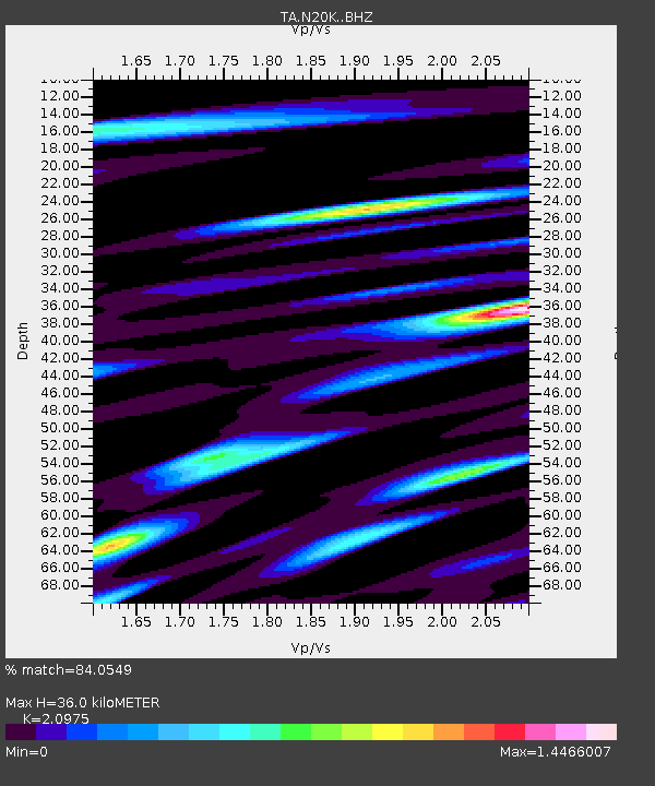
| Estimated Moho Depth: |
36.0 km |
| Estimated Crust Vp/Vs: |
2.10 |
| Assumed Crust Vp: |
6.566 km/s |
| Estimated Crust Vs: |
3.13 km/s |
| Estimated Crust Poisson's Ratio: |
0.35 |
|
| Radial Match: |
84.0549 % |
| Radial Bump: |
400 |
| Transverse Match: |
87.43918 % |
| Transverse Bump: |
400 |
| SOD ConfigId: |
11737051 |
| Insert Time: |
2019-04-25 01:28:07.318 +0000 |
| GWidth: |
2.5 |
| Max Bumps: |
400 |
| Tol: |
0.001 |
|

Signal To Noise
| Channel | StoN | STA | LTA |
| TA:N20K: :BHZ:20160711T02:12:52.974973Z | 7.685655 | 4.564259E-7 | 5.938673E-8 |
| TA:N20K: :BHN:20160711T02:12:52.974973Z | 2.3157086 | 1.391376E-7 | 6.008424E-8 |
| TA:N20K: :BHE:20160711T02:12:52.974973Z | 2.4990695 | 1.7359409E-7 | 6.946349E-8 |
| Arrivals |
| Ps | 6.2 SECOND |
| PpPs | 17 SECOND |
| PsPs/PpSs | 23 SECOND |


