You are here: Home > Network List > TA - USArray Transportable Network (new EarthScope stations) Stations List
> Station P33M Teslin, Yukon, CA > Earthquake Result Viewer
P33M Teslin, Yukon, CA - Earthquake Result Viewer
| Earthquake location: |
Near Coast Of Ecuador |
| Earthquake latitude/longitude: |
0.6/-79.6 |
| Earthquake time(UTC): |
2016/07/11 (193) 02:01:09 GMT |
| Earthquake Depth: |
14 km |
| Earthquake Magnitude: |
5.8 MWW, 5.7 MWB, 5.9 MWC |
| Earthquake Catalog/Contributor: |
NEIC PDE/NEIC COMCAT |
|
| Network: |
TA USArray Transportable Network (new EarthScope stations) |
| Station: |
P33M Teslin, Yukon, CA |
| Lat/Lon: |
60.21 N/132.82 W |
| Elevation: |
1066 m |
|
| Distance: |
72.1 deg |
| Az: |
335.16 deg |
| Baz: |
122.726 deg |
| Ray Param: |
0.053899013 |
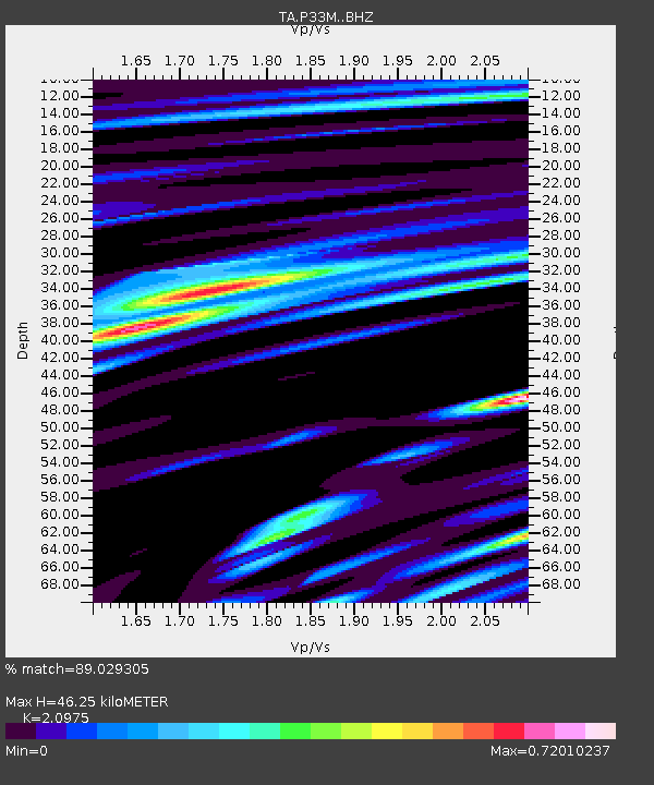
| Estimated Moho Depth: |
46.25 km |
| Estimated Crust Vp/Vs: |
2.10 |
| Assumed Crust Vp: |
6.419 km/s |
| Estimated Crust Vs: |
3.06 km/s |
| Estimated Crust Poisson's Ratio: |
0.35 |
|
| Radial Match: |
89.029305 % |
| Radial Bump: |
400 |
| Transverse Match: |
89.861244 % |
| Transverse Bump: |
400 |
| SOD ConfigId: |
11737051 |
| Insert Time: |
2019-04-25 01:28:22.247 +0000 |
| GWidth: |
2.5 |
| Max Bumps: |
400 |
| Tol: |
0.001 |
|

Signal To Noise
| Channel | StoN | STA | LTA |
| TA:P33M: :BHZ:20160711T02:12:01.749021Z | 8.534653 | 4.9881737E-7 | 5.844612E-8 |
| TA:P33M: :BHN:20160711T02:12:01.749021Z | 2.8966663 | 1.584312E-7 | 5.4694322E-8 |
| TA:P33M: :BHE:20160711T02:12:01.749021Z | 2.2996418 | 1.2782908E-7 | 5.558652E-8 |
| Arrivals |
| Ps | 8.1 SECOND |
| PpPs | 22 SECOND |
| PsPs/PpSs | 30 SECOND |


