You are here: Home > Network List > TA - USArray Transportable Network (new EarthScope stations) Stations List
> Station T25A Trinidad, CO, USA > Earthquake Result Viewer
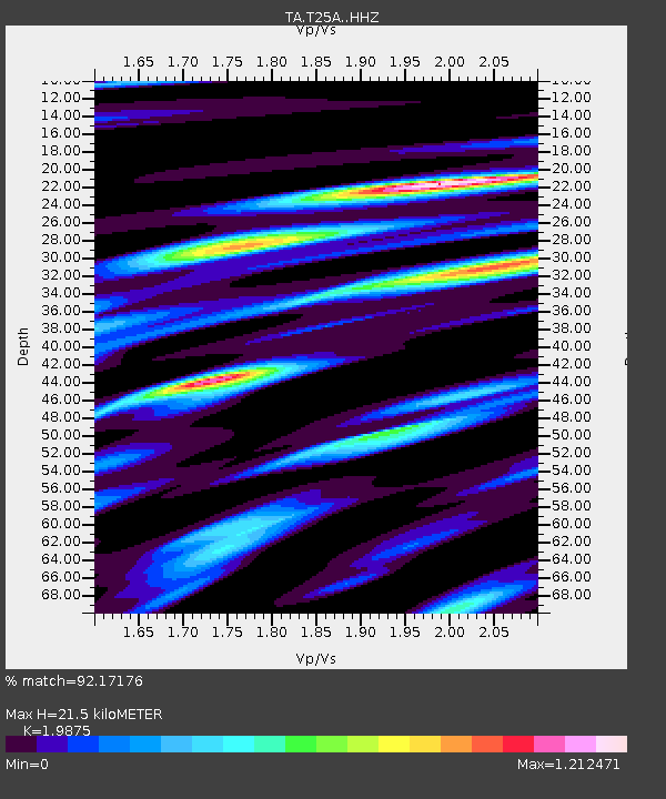
T25A Trinidad, CO, USA - Earthquake Result Viewer
| Earthquake location: |
Near Coast Of Ecuador |
| Earthquake latitude/longitude: |
0.6/-79.6 |
| Earthquake time(UTC): |
2016/07/11 (193) 02:01:09 GMT |
| Earthquake Depth: |
14 km |
| Earthquake Magnitude: |
5.8 MWW, 5.7 MWB, 5.9 MWC |
| Earthquake Catalog/Contributor: |
NEIC PDE/NEIC COMCAT |
|
| Network: |
TA USArray Transportable Network (new EarthScope stations) |
| Station: |
T25A Trinidad, CO, USA |
| Lat/Lon: |
37.14 N/104.41 W |
| Elevation: |
2017 m |
|
| Distance: |
43.0 deg |
| Az: |
330.594 deg |
| Baz: |
142.092 deg |
| Ray Param: |
0.07283262 |
| Estimated Moho Depth: |
21.5 km |
| Estimated Crust Vp/Vs: |
1.99 |
| Assumed Crust Vp: |
6.316 km/s |
| Estimated Crust Vs: |
3.178 km/s |
| Estimated Crust Poisson's Ratio: |
0.33 |
|
| Radial Match: |
92.17176 % |
| Radial Bump: |
305 |
| Transverse Match: |
73.5467 % |
| Transverse Bump: |
400 |
| SOD ConfigId: |
11737051 |
| Insert Time: |
2019-04-25 01:28:33.013 +0000 |
| GWidth: |
2.5 |
| Max Bumps: |
400 |
| Tol: |
0.001 |
|

Signal To Noise
| Channel | StoN | STA | LTA |
| TA:T25A: :HHZ:20160711T02:08:37.239988Z | 5.0028095 | 4.0861823E-7 | 8.1677754E-8 |
| TA:T25A: :HHN:20160711T02:08:37.239988Z | 3.1761396 | 2.0926238E-7 | 6.5885764E-8 |
| TA:T25A: :HHE:20160711T02:08:37.239988Z | 4.472881 | 1.9116287E-7 | 4.2738197E-8 |
| Arrivals |
| Ps | 3.6 SECOND |
| PpPs | 9.6 SECOND |
| PsPs/PpSs | 13 SECOND |


