You are here: Home > Network List > TA - USArray Transportable Network (new EarthScope stations) Stations List
> Station TCOL CIGO, UAF Yankovich Road, Fairbanks, AK, USA > Earthquake Result Viewer
TCOL CIGO, UAF Yankovich Road, Fairbanks, AK, USA - Earthquake Result Viewer
| Earthquake location: |
Near Coast Of Ecuador |
| Earthquake latitude/longitude: |
0.6/-79.6 |
| Earthquake time(UTC): |
2016/07/11 (193) 02:01:09 GMT |
| Earthquake Depth: |
14 km |
| Earthquake Magnitude: |
5.8 MWW, 5.7 MWB, 5.9 MWC |
| Earthquake Catalog/Contributor: |
NEIC PDE/NEIC COMCAT |
|
| Network: |
TA USArray Transportable Network (new EarthScope stations) |
| Station: |
TCOL CIGO, UAF Yankovich Road, Fairbanks, AK, USA |
| Lat/Lon: |
64.87 N/147.86 W |
| Elevation: |
178 m |
|
| Distance: |
80.4 deg |
| Az: |
336.288 deg |
| Baz: |
109.637 deg |
| Ray Param: |
0.048320748 |
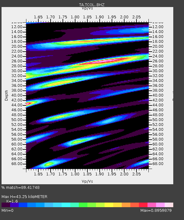
| Estimated Moho Depth: |
43.25 km |
| Estimated Crust Vp/Vs: |
1.60 |
| Assumed Crust Vp: |
6.566 km/s |
| Estimated Crust Vs: |
4.104 km/s |
| Estimated Crust Poisson's Ratio: |
0.18 |
|
| Radial Match: |
89.41748 % |
| Radial Bump: |
400 |
| Transverse Match: |
79.73597 % |
| Transverse Bump: |
400 |
| SOD ConfigId: |
11737051 |
| Insert Time: |
2019-04-25 01:28:33.609 +0000 |
| GWidth: |
2.5 |
| Max Bumps: |
400 |
| Tol: |
0.001 |
|

Signal To Noise
| Channel | StoN | STA | LTA |
| TA:TCOL: :BHZ:20160711T02:12:48.775022Z | 6.8612914 | 3.9009845E-7 | 5.6854958E-8 |
| TA:TCOL: :BHN:20160711T02:12:48.775022Z | 1.9652072 | 1.1491815E-7 | 5.8476353E-8 |
| TA:TCOL: :BHE:20160711T02:12:48.775022Z | 2.5838299 | 1.532921E-7 | 5.9327476E-8 |
| Arrivals |
| Ps | 4.1 SECOND |
| PpPs | 17 SECOND |
| PsPs/PpSs | 21 SECOND |


