You are here: Home > Network List > TA - USArray Transportable Network (new EarthScope stations) Stations List
> Station WHTX Lake Whitney, Meridian, TX, USA > Earthquake Result Viewer
WHTX Lake Whitney, Meridian, TX, USA - Earthquake Result Viewer
| Earthquake location: |
Near Coast Of Ecuador |
| Earthquake latitude/longitude: |
0.6/-79.6 |
| Earthquake time(UTC): |
2016/07/11 (193) 02:01:09 GMT |
| Earthquake Depth: |
14 km |
| Earthquake Magnitude: |
5.8 MWW, 5.7 MWB, 5.9 MWC |
| Earthquake Catalog/Contributor: |
NEIC PDE/NEIC COMCAT |
|
| Network: |
TA USArray Transportable Network (new EarthScope stations) |
| Station: |
WHTX Lake Whitney, Meridian, TX, USA |
| Lat/Lon: |
31.99 N/97.46 W |
| Elevation: |
190 m |
|
| Distance: |
35.5 deg |
| Az: |
333.407 deg |
| Baz: |
148.211 deg |
| Ray Param: |
0.07718428 |
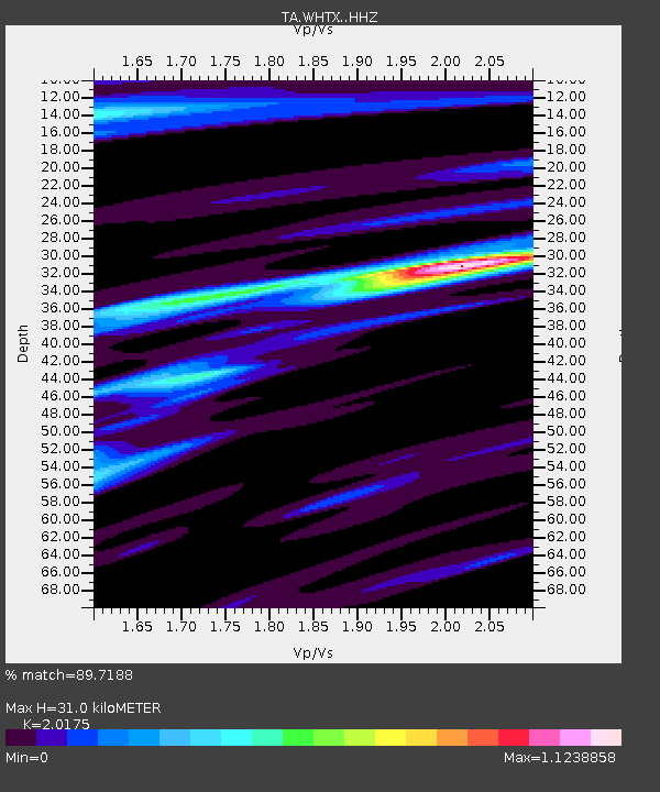
| Estimated Moho Depth: |
31.0 km |
| Estimated Crust Vp/Vs: |
2.02 |
| Assumed Crust Vp: |
6.347 km/s |
| Estimated Crust Vs: |
3.146 km/s |
| Estimated Crust Poisson's Ratio: |
0.34 |
|
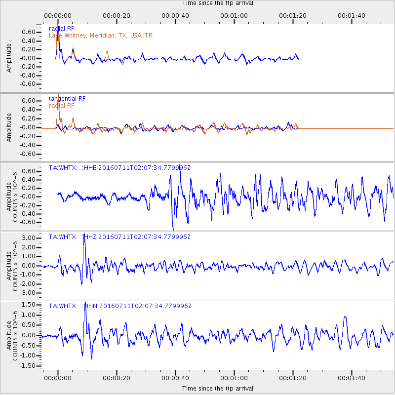
| Radial Match: |
89.7188 % |
| Radial Bump: |
250 |
| Transverse Match: |
66.11545 % |
| Transverse Bump: |
268 |
| SOD ConfigId: |
11737051 |
| Insert Time: |
2019-04-25 01:28:38.167 +0000 |
| GWidth: |
2.5 |
| Max Bumps: |
400 |
| Tol: |
0.001 |
|
Signal To Noise
| Channel | StoN | STA | LTA |
| TA:WHTX: :HHZ:20160711T02:07:34.779996Z | 5.398234 | 5.073337E-7 | 9.398143E-8 |
| TA:WHTX: :HHN:20160711T02:07:34.779996Z | 4.2306767 | 2.1360762E-7 | 5.049018E-8 |
| TA:WHTX: :HHE:20160711T02:07:34.779996Z | 2.4616706 | 1.536605E-7 | 6.242122E-8 |
| Arrivals |
| Ps | 5.3 SECOND |
| PpPs | 14 SECOND |
| PsPs/PpSs | 19 SECOND |


