You are here: Home > Network List > TD - TransAlta Monitoring Network Stations List
> Station TD011 Z > Earthquake Result Viewer
TD011 Z - Earthquake Result Viewer
| Earthquake location: |
Near Coast Of Ecuador |
| Earthquake latitude/longitude: |
0.6/-79.6 |
| Earthquake time(UTC): |
2016/07/11 (193) 02:01:09 GMT |
| Earthquake Depth: |
14 km |
| Earthquake Magnitude: |
5.8 MWW, 5.7 MWB, 5.9 MWC |
| Earthquake Catalog/Contributor: |
NEIC PDE/NEIC COMCAT |
|
| Network: |
TD TransAlta Monitoring Network |
| Station: |
TD011 Z |
| Lat/Lon: |
52.55 N/115.52 W |
| Elevation: |
1103 m |
|
| Distance: |
59.8 deg |
| Az: |
335.55 deg |
| Baz: |
137.33 deg |
| Ray Param: |
0.061926555 |
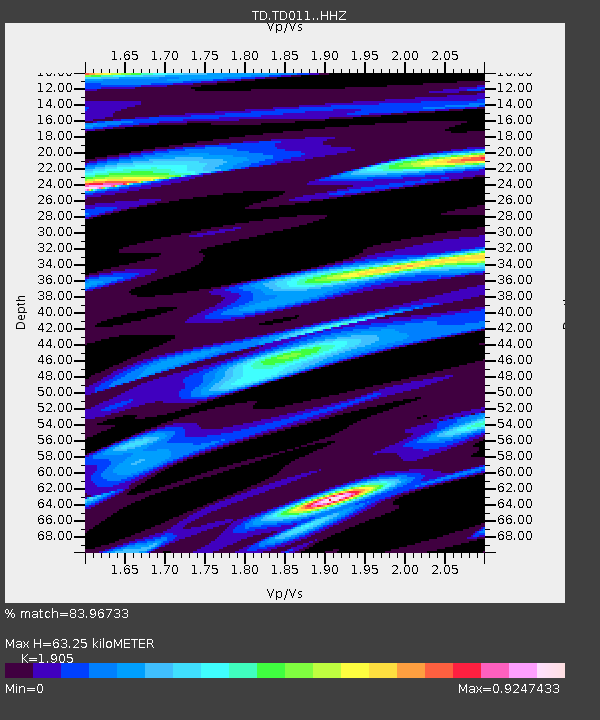
| Estimated Moho Depth: |
63.25 km |
| Estimated Crust Vp/Vs: |
1.90 |
| Assumed Crust Vp: |
6.426 km/s |
| Estimated Crust Vs: |
3.373 km/s |
| Estimated Crust Poisson's Ratio: |
0.31 |
|
| Radial Match: |
83.96733 % |
| Radial Bump: |
400 |
| Transverse Match: |
72.31278 % |
| Transverse Bump: |
400 |
| SOD ConfigId: |
11737051 |
| Insert Time: |
2019-04-25 01:28:42.397 +0000 |
| GWidth: |
2.5 |
| Max Bumps: |
400 |
| Tol: |
0.001 |
|

Signal To Noise
| Channel | StoN | STA | LTA |
| TD:TD011: :HHZ:20160711T02:10:43.150022Z | 11.415485 | 8.1694884E-7 | 7.156497E-8 |
| TD:TD011: :HH1:20160711T02:10:43.150022Z | 1.8200257 | 1.864526E-7 | 1.02445036E-7 |
| TD:TD011: :HH2:20160711T02:10:43.150022Z | 3.235038 | 2.622281E-7 | 8.105874E-8 |
| Arrivals |
| Ps | 9.3 SECOND |
| PpPs | 27 SECOND |
| PsPs/PpSs | 37 SECOND |


