You are here: Home > Network List > US - United States National Seismic Network Stations List
> Station HAWA Hanford, Washington, USA > Earthquake Result Viewer
HAWA Hanford, Washington, USA - Earthquake Result Viewer
| Earthquake location: |
Solomon Islands |
| Earthquake latitude/longitude: |
-10.5/160.8 |
| Earthquake time(UTC): |
2003/01/20 (020) 08:43:06 GMT |
| Earthquake Depth: |
33 km |
| Earthquake Magnitude: |
6.7 MB, 7.8 MS, 7.3 MW, 7.2 MW |
| Earthquake Catalog/Contributor: |
WHDF/NEIC |
|
| Network: |
US United States National Seismic Network |
| Station: |
HAWA Hanford, Washington, USA |
| Lat/Lon: |
46.39 N/119.53 W |
| Elevation: |
364 m |
|
| Distance: |
90.5 deg |
| Az: |
42.922 deg |
| Baz: |
255.394 deg |
| Ray Param: |
0.041664585 |
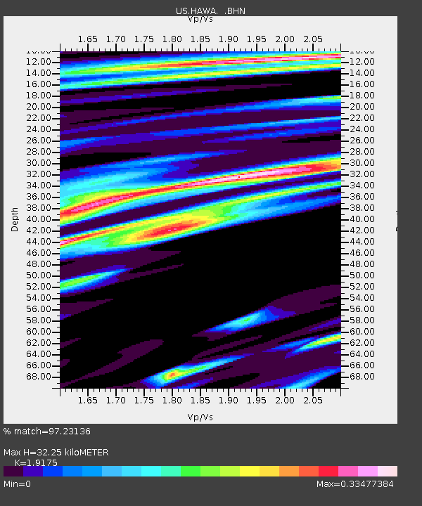
| Estimated Moho Depth: |
32.25 km |
| Estimated Crust Vp/Vs: |
1.92 |
| Assumed Crust Vp: |
6.419 km/s |
| Estimated Crust Vs: |
3.348 km/s |
| Estimated Crust Poisson's Ratio: |
0.31 |
|
| Radial Match: |
97.23136 % |
| Radial Bump: |
400 |
| Transverse Match: |
87.48498 % |
| Transverse Bump: |
400 |
| SOD ConfigId: |
110177 |
| Insert Time: |
2010-03-05 05:13:55.950 +0000 |
| GWidth: |
2.5 |
| Max Bumps: |
400 |
| Tol: |
0.001 |
|

Signal To Noise
| Channel | StoN | STA | LTA |
| US:HAWA: :BHN:20030120T08:55:33.262993Z | 0.6367856 | 1.00215196E-7 | 1.5737666E-7 |
| US:HAWA: :BHE:20030120T08:55:33.262993Z | 2.7803097 | 4.2774928E-7 | 1.5384951E-7 |
| US:HAWA: :BHZ:20030120T08:55:33.262993Z | 9.739857 | 2.4737324E-6 | 2.5398037E-7 |
| Arrivals |
| Ps | 4.7 SECOND |
| PpPs | 14 SECOND |
| PsPs/PpSs | 19 SECOND |


