You are here: Home > Network List > US - United States National Seismic Network Stations List
> Station HAWA Hanford, Washington, USA > Earthquake Result Viewer
HAWA Hanford, Washington, USA - Earthquake Result Viewer

| Earthquake location: |
Western Brazil |
| Earthquake latitude/longitude: |
-7.6/-71.7 |
| Earthquake time(UTC): |
2003/06/20 (171) 06:19:38 GMT |
| Earthquake Depth: |
558 km |
| Earthquake Magnitude: |
6.4 MB, 7.1 MW, 7.0 MW |
| Earthquake Catalog/Contributor: |
WHDF/NEIC |
|
| Network: |
US United States National Seismic Network |
| Station: |
HAWA Hanford, Washington, USA |
| Lat/Lon: |
46.39 N/119.53 W |
| Elevation: |
364 m |
|
| Distance: |
68.5 deg |
| Az: |
326.562 deg |
| Baz: |
127.887 deg |
| Ray Param: |
0.054293215 |
| Estimated Moho Depth: |
11.5 km |
| Estimated Crust Vp/Vs: |
1.60 |
| Assumed Crust Vp: |
6.419 km/s |
| Estimated Crust Vs: |
4.012 km/s |
| Estimated Crust Poisson's Ratio: |
0.18 |
|
| Radial Match: |
92.62049 % |
| Radial Bump: |
400 |
| Transverse Match: |
82.59574 % |
| Transverse Bump: |
400 |
| SOD ConfigId: |
110177 |
| Insert Time: |
2010-03-05 05:14:18.279 +0000 |
| GWidth: |
2.5 |
| Max Bumps: |
400 |
| Tol: |
0.001 |
|
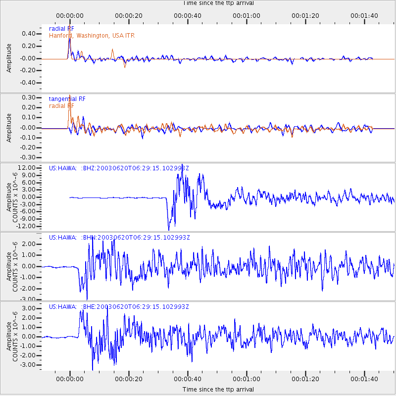
Signal To Noise
| Channel | StoN | STA | LTA |
| US:HAWA: :BHN:20030620T06:29:15.102993Z | 18.671137 | 9.093459E-7 | 4.87033E-8 |
| US:HAWA: :BHE:20030620T06:29:15.102993Z | 29.193064 | 1.1956697E-6 | 4.095732E-8 |
| US:HAWA: :BHZ:20030620T06:29:15.102993Z | 62.11206 | 5.2552446E-6 | 8.4609084E-8 |
| Arrivals |
| Ps | 1.1 SECOND |
| PpPs | 4.5 SECOND |
| PsPs/PpSs | 5.6 SECOND |


