You are here: Home > Network List > 7A - Mid-Atlantic Geophysical Integrative Collaboration Stations List
> Station WLFT Gordonsville, Virginia USA > Earthquake Result Viewer
WLFT Gordonsville, Virginia USA - Earthquake Result Viewer
| Earthquake location: |
Near Coast Of Ecuador |
| Earthquake latitude/longitude: |
0.6/-79.7 |
| Earthquake time(UTC): |
2016/07/11 (193) 02:11:04 GMT |
| Earthquake Depth: |
19 km |
| Earthquake Magnitude: |
6.3 MWW, 6.3 MWC, 6.3 MWB |
| Earthquake Catalog/Contributor: |
NEIC PDE/NEIC COMCAT |
|
| Network: |
7A Mid-Atlantic Geophysical Integrative Collaboration |
| Station: |
WLFT Gordonsville, Virginia USA |
| Lat/Lon: |
38.17 N/78.14 W |
| Elevation: |
110 m |
|
| Distance: |
37.5 deg |
| Az: |
1.969 deg |
| Baz: |
182.499 deg |
| Ray Param: |
0.0761045 |
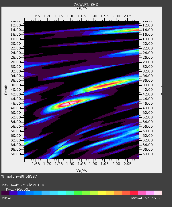
| Estimated Moho Depth: |
45.75 km |
| Estimated Crust Vp/Vs: |
1.80 |
| Assumed Crust Vp: |
6.159 km/s |
| Estimated Crust Vs: |
3.431 km/s |
| Estimated Crust Poisson's Ratio: |
0.27 |
|
| Radial Match: |
89.56537 % |
| Radial Bump: |
345 |
| Transverse Match: |
47.354523 % |
| Transverse Bump: |
400 |
| SOD ConfigId: |
11737051 |
| Insert Time: |
2019-04-25 01:32:02.131 +0000 |
| GWidth: |
2.5 |
| Max Bumps: |
400 |
| Tol: |
0.001 |
|

Signal To Noise
| Channel | StoN | STA | LTA |
| 7A:WLFT: :BHZ:20160711T02:17:45.680001Z | 4.5909495 | 1.6553607E-6 | 3.6057045E-7 |
| 7A:WLFT: :BHN:20160711T02:17:45.680001Z | 4.3459373 | 1.2929933E-6 | 2.9751772E-7 |
| 7A:WLFT: :BHE:20160711T02:17:45.680001Z | 0.72183406 | 6.1628793E-7 | 8.537806E-7 |
| Arrivals |
| Ps | 6.3 SECOND |
| PpPs | 19 SECOND |
| PsPs/PpSs | 26 SECOND |


