You are here: Home > Network List > US - United States National Seismic Network Stations List
> Station HAWA Hanford, Washington, USA > Earthquake Result Viewer
HAWA Hanford, Washington, USA - Earthquake Result Viewer
*The percent match for this event was below the threshold and hence no stack was calculated.
| Earthquake location: |
Southeast Of Loyalty Islands |
| Earthquake latitude/longitude: |
-22.4/170.6 |
| Earthquake time(UTC): |
2009/01/15 (015) 07:27:20 GMT |
| Earthquake Depth: |
27 km |
| Earthquake Magnitude: |
5.8 MB, 6.5 MS, 6.7 MW, 6.6 MW |
| Earthquake Catalog/Contributor: |
WHDF/NEIC |
|
| Network: |
US United States National Seismic Network |
| Station: |
HAWA Hanford, Washington, USA |
| Lat/Lon: |
46.39 N/119.53 W |
| Elevation: |
364 m |
|
| Distance: |
93.0 deg |
| Az: |
40.586 deg |
| Baz: |
240.479 deg |
| Ray Param: |
$rayparam |
*The percent match for this event was below the threshold and hence was not used in the summary stack. |
|
| Radial Match: |
81.518234 % |
| Radial Bump: |
400 |
| Transverse Match: |
47.120502 % |
| Transverse Bump: |
400 |
| SOD ConfigId: |
2834 |
| Insert Time: |
2010-03-05 05:14:43.290 +0000 |
| GWidth: |
2.5 |
| Max Bumps: |
400 |
| Tol: |
0.001 |
|
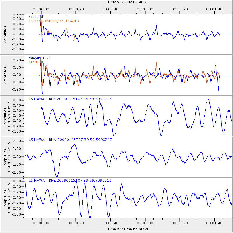
Signal To Noise
| Channel | StoN | STA | LTA |
| US:HAWA: :BHN:20090115T07:39:59.599021Z | 2.6503599 | 6.407573E-7 | 2.417624E-7 |
| US:HAWA: :BHE:20090115T07:39:59.599021Z | 0.5872893 | 1.9570902E-7 | 3.3324127E-7 |
| US:HAWA: :BHZ:20090115T07:39:59.599021Z | 1.9478568 | 3.7321516E-7 | 1.9160298E-7 |
| Arrivals |
| Ps | |
| PpPs | |
| PsPs/PpSs | |


