You are here: Home > Network List > US - United States National Seismic Network Stations List
> Station HAWA Hanford, Washington, USA > Earthquake Result Viewer
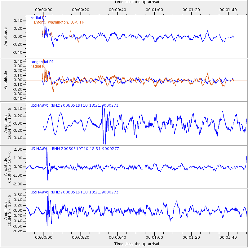
HAWA Hanford, Washington, USA - Earthquake Result Viewer
*The percent match for this event was below the threshold and hence no stack was calculated.
| Earthquake location: |
E. Russia-N.E. China Border Reg. |
| Earthquake latitude/longitude: |
42.5/131.9 |
| Earthquake time(UTC): |
2008/05/19 (140) 10:08:36 GMT |
| Earthquake Depth: |
513 km |
| Earthquake Magnitude: |
5.7 MW, 5.4 MB, 5.6 MW |
| Earthquake Catalog/Contributor: |
WHDF/NEIC |
|
| Network: |
US United States National Seismic Network |
| Station: |
HAWA Hanford, Washington, USA |
| Lat/Lon: |
46.39 N/119.53 W |
| Elevation: |
364 m |
|
| Distance: |
71.2 deg |
| Az: |
43.874 deg |
| Baz: |
312.227 deg |
| Ray Param: |
$rayparam |
*The percent match for this event was below the threshold and hence was not used in the summary stack. |
|
| Radial Match: |
73.54179 % |
| Radial Bump: |
400 |
| Transverse Match: |
58.630733 % |
| Transverse Bump: |
318 |
| SOD ConfigId: |
2504 |
| Insert Time: |
2010-03-05 05:14:58.337 +0000 |
| GWidth: |
2.5 |
| Max Bumps: |
400 |
| Tol: |
0.001 |
|
Signal To Noise
| Channel | StoN | STA | LTA |
| US:HAWA: :BHN:20080519T10:18:31.900027Z | 3.6384382 | 6.8635137E-7 | 1.88639E-7 |
| US:HAWA: :BHE:20080519T10:18:31.900027Z | 2.3850665 | 2.8177277E-7 | 1.1814043E-7 |
| US:HAWA: :BHZ:20080519T10:18:31.900027Z | 1.7521617 | 2.5525884E-7 | 1.4568224E-7 |
| Arrivals |
| Ps | |
| PpPs | |
| PsPs/PpSs | |


