You are here: Home > Network List > US - United States National Seismic Network Stations List
> Station HAWA Hanford, Washington, USA > Earthquake Result Viewer
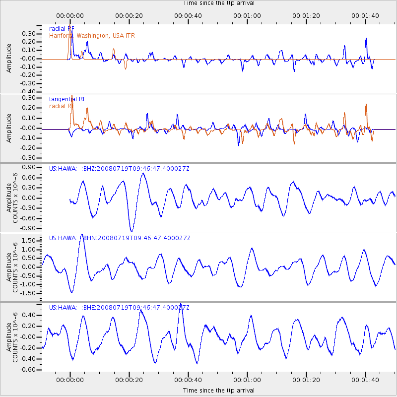
HAWA Hanford, Washington, USA - Earthquake Result Viewer
*The percent match for this event was below the threshold and hence no stack was calculated.
| Earthquake location: |
Santa Cruz Islands Region |
| Earthquake latitude/longitude: |
-11.0/164.5 |
| Earthquake time(UTC): |
2008/07/19 (201) 09:34:26 GMT |
| Earthquake Depth: |
10 km |
| Earthquake Magnitude: |
5.5 MB |
| Earthquake Catalog/Contributor: |
WHDF/NEIC |
|
| Network: |
US United States National Seismic Network |
| Station: |
HAWA Hanford, Washington, USA |
| Lat/Lon: |
46.39 N/119.53 W |
| Elevation: |
364 m |
|
| Distance: |
88.4 deg |
| Az: |
42.195 deg |
| Baz: |
252.301 deg |
| Ray Param: |
$rayparam |
*The percent match for this event was below the threshold and hence was not used in the summary stack. |
|
| Radial Match: |
59.660175 % |
| Radial Bump: |
400 |
| Transverse Match: |
54.029316 % |
| Transverse Bump: |
314 |
| SOD ConfigId: |
2504 |
| Insert Time: |
2010-03-05 05:15:12.091 +0000 |
| GWidth: |
2.5 |
| Max Bumps: |
400 |
| Tol: |
0.001 |
|
Signal To Noise
| Channel | StoN | STA | LTA |
| US:HAWA: :BHN:20080719T09:46:47.400027Z | 2.6435542 | 1.2300302E-6 | 4.652941E-7 |
| US:HAWA: :BHE:20080719T09:46:47.400027Z | 1.034255 | 2.6954405E-7 | 2.6061662E-7 |
| US:HAWA: :BHZ:20080719T09:46:47.400027Z | 0.7388598 | 2.9523878E-7 | 3.99587E-7 |
| Arrivals |
| Ps | |
| PpPs | |
| PsPs/PpSs | |


