You are here: Home > Network List > US - United States National Seismic Network Stations List
> Station HAWA Hanford, Washington, USA > Earthquake Result Viewer
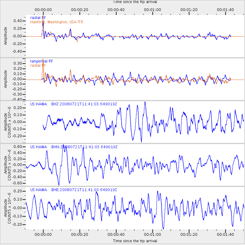
HAWA Hanford, Washington, USA - Earthquake Result Viewer
*The percent match for this event was below the threshold and hence no stack was calculated.
| Earthquake location: |
Off East Coast Of Honshu, Japan |
| Earthquake latitude/longitude: |
37.2/142.1 |
| Earthquake time(UTC): |
2008/07/21 (203) 11:30:29 GMT |
| Earthquake Depth: |
22 km |
| Earthquake Magnitude: |
5.7 MB, 5.6 MS, 6.0 MW, 5.9 MW |
| Earthquake Catalog/Contributor: |
WHDF/NEIC |
|
| Network: |
US United States National Seismic Network |
| Station: |
HAWA Hanford, Washington, USA |
| Lat/Lon: |
46.39 N/119.53 W |
| Elevation: |
364 m |
|
| Distance: |
69.3 deg |
| Az: |
47.049 deg |
| Baz: |
302.377 deg |
| Ray Param: |
$rayparam |
*The percent match for this event was below the threshold and hence was not used in the summary stack. |
|
| Radial Match: |
76.04364 % |
| Radial Bump: |
400 |
| Transverse Match: |
67.41371 % |
| Transverse Bump: |
400 |
| SOD ConfigId: |
2504 |
| Insert Time: |
2010-03-05 05:15:12.995 +0000 |
| GWidth: |
2.5 |
| Max Bumps: |
400 |
| Tol: |
0.001 |
|
Signal To Noise
| Channel | StoN | STA | LTA |
| US:HAWA: :BHN:20080721T11:41:03.649019Z | 3.4221954 | 2.0560734E-7 | 6.008053E-8 |
| US:HAWA: :BHE:20080721T11:41:03.649019Z | 1.3389612 | 7.0158634E-8 | 5.2397805E-8 |
| US:HAWA: :BHZ:20080721T11:41:03.649019Z | 1.7057616 | 7.7488494E-8 | 4.5427505E-8 |
| Arrivals |
| Ps | |
| PpPs | |
| PsPs/PpSs | |


