You are here: Home > Network List > US - United States National Seismic Network Stations List
> Station HAWA Hanford, Washington, USA > Earthquake Result Viewer
HAWA Hanford, Washington, USA - Earthquake Result Viewer
*The percent match for this event was below the threshold and hence no stack was calculated.
| Earthquake location: |
Tonga Islands |
| Earthquake latitude/longitude: |
-18.4/-175.4 |
| Earthquake time(UTC): |
2008/10/22 (296) 12:55:57 GMT |
| Earthquake Depth: |
233 km |
| Earthquake Magnitude: |
5.9 MB, 6.4 MW, 6.3 MW |
| Earthquake Catalog/Contributor: |
WHDF/NEIC |
|
| Network: |
US United States National Seismic Network |
| Station: |
HAWA Hanford, Washington, USA |
| Lat/Lon: |
46.39 N/119.53 W |
| Elevation: |
364 m |
|
| Distance: |
81.8 deg |
| Az: |
35.344 deg |
| Baz: |
232.517 deg |
| Ray Param: |
$rayparam |
*The percent match for this event was below the threshold and hence was not used in the summary stack. |
|
| Radial Match: |
43.938953 % |
| Radial Bump: |
400 |
| Transverse Match: |
56.865887 % |
| Transverse Bump: |
400 |
| SOD ConfigId: |
2560 |
| Insert Time: |
2010-03-05 05:15:23.629 +0000 |
| GWidth: |
2.5 |
| Max Bumps: |
400 |
| Tol: |
0.001 |
|
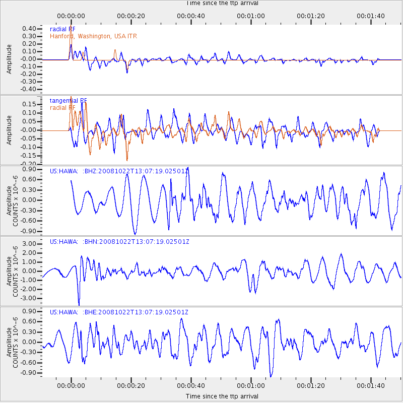
Signal To Noise
| Channel | StoN | STA | LTA |
| US:HAWA: :BHN:20081022T13:07:19.02501Z | 3.2492826 | 1.3006319E-6 | 4.0028277E-7 |
| US:HAWA: :BHE:20081022T13:07:19.02501Z | 1.3942175 | 4.1926864E-7 | 3.007197E-7 |
| US:HAWA: :BHZ:20081022T13:07:19.02501Z | 0.90983105 | 3.6206418E-7 | 3.9794662E-7 |
| Arrivals |
| Ps | |
| PpPs | |
| PsPs/PpSs | |


