You are here: Home > Network List > US - United States National Seismic Network Stations List
> Station HAWA Hanford, Washington, USA > Earthquake Result Viewer
HAWA Hanford, Washington, USA - Earthquake Result Viewer
*The percent match for this event was below the threshold and hence no stack was calculated.
| Earthquake location: |
Arctic Ocean |
| Earthquake latitude/longitude: |
79.6/-116.1 |
| Earthquake time(UTC): |
2008/11/17 (322) 12:55:22 GMT |
| Earthquake Depth: |
7.0 km |
| Earthquake Magnitude: |
5.7 MW, 5.2 MS, 5.4 MB, 5.7 MW |
| Earthquake Catalog/Contributor: |
WHDF/NEIC |
|
| Network: |
US United States National Seismic Network |
| Station: |
HAWA Hanford, Washington, USA |
| Lat/Lon: |
46.39 N/119.53 W |
| Elevation: |
364 m |
|
| Distance: |
33.4 deg |
| Az: |
184.372 deg |
| Baz: |
1.142 deg |
| Ray Param: |
$rayparam |
*The percent match for this event was below the threshold and hence was not used in the summary stack. |
|
| Radial Match: |
56.31385 % |
| Radial Bump: |
400 |
| Transverse Match: |
57.456104 % |
| Transverse Bump: |
345 |
| SOD ConfigId: |
2658 |
| Insert Time: |
2010-03-05 05:15:24.216 +0000 |
| GWidth: |
2.5 |
| Max Bumps: |
400 |
| Tol: |
0.001 |
|
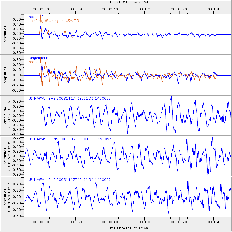
Signal To Noise
| Channel | StoN | STA | LTA |
| US:HAWA: :BHN:20081117T13:01:31.149009Z | 1.0460888 | 1.7885347E-7 | 1.7097351E-7 |
| US:HAWA: :BHE:20081117T13:01:31.149009Z | 2.9397717 | 2.6325685E-7 | 8.9550106E-8 |
| US:HAWA: :BHZ:20081117T13:01:31.149009Z | 1.249945 | 1.5364286E-7 | 1.2291969E-7 |
| Arrivals |
| Ps | |
| PpPs | |
| PsPs/PpSs | |


