You are here: Home > Network List > US - United States National Seismic Network Stations List
> Station HAWA Hanford, Washington, USA > Earthquake Result Viewer
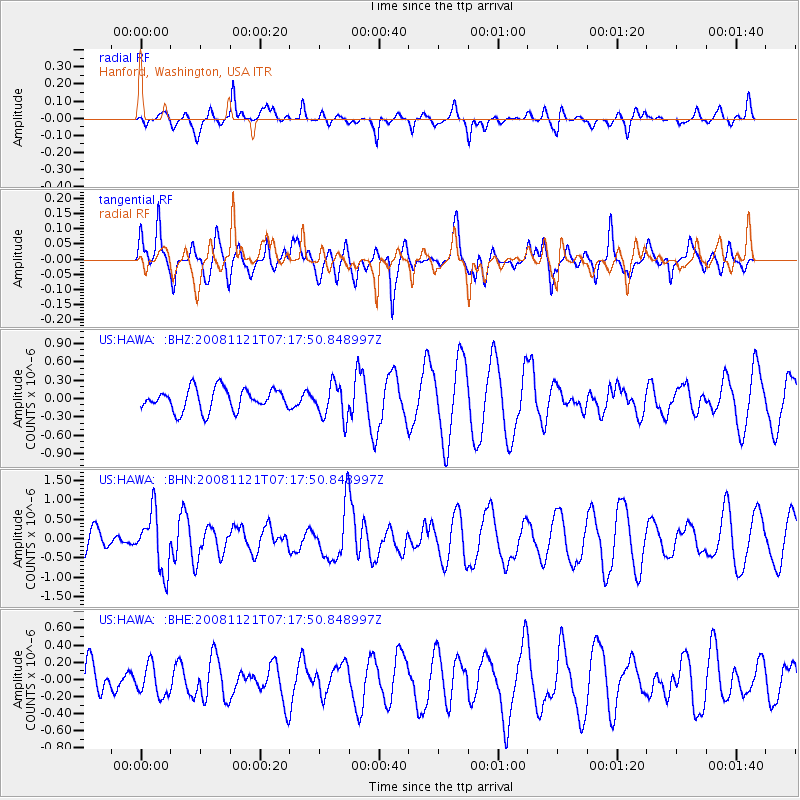
HAWA Hanford, Washington, USA - Earthquake Result Viewer
*The percent match for this event was below the threshold and hence no stack was calculated.
| Earthquake location: |
Solomon Islands |
| Earthquake latitude/longitude: |
-8.9/159.6 |
| Earthquake time(UTC): |
2008/11/21 (326) 07:05:34 GMT |
| Earthquake Depth: |
118 km |
| Earthquake Magnitude: |
6.0 MB, 6.1 MW, 6.0 MW |
| Earthquake Catalog/Contributor: |
WHDF/NEIC |
|
| Network: |
US United States National Seismic Network |
| Station: |
HAWA Hanford, Washington, USA |
| Lat/Lon: |
46.39 N/119.53 W |
| Elevation: |
364 m |
|
| Distance: |
90.2 deg |
| Az: |
43.115 deg |
| Baz: |
257.318 deg |
| Ray Param: |
$rayparam |
*The percent match for this event was below the threshold and hence was not used in the summary stack. |
|
| Radial Match: |
35.131836 % |
| Radial Bump: |
299 |
| Transverse Match: |
56.233833 % |
| Transverse Bump: |
360 |
| SOD ConfigId: |
2658 |
| Insert Time: |
2010-03-05 05:15:26.696 +0000 |
| GWidth: |
2.5 |
| Max Bumps: |
400 |
| Tol: |
0.001 |
|
Signal To Noise
| Channel | StoN | STA | LTA |
| US:HAWA: :BHN:20081121T07:17:50.848997Z | 2.8978217 | 7.429368E-7 | 2.563777E-7 |
| US:HAWA: :BHE:20081121T07:17:50.848997Z | 0.61216027 | 1.7765083E-7 | 2.9020313E-7 |
| US:HAWA: :BHZ:20081121T07:17:50.848997Z | 1.5836755 | 2.808278E-7 | 1.7732661E-7 |
| Arrivals |
| Ps | |
| PpPs | |
| PsPs/PpSs | |


