You are here: Home > Network List > LD - Lamont-Doherty Cooperative Seismographic Network Stations List
> Station BRNJ Basking Ridge, New Jersey > Earthquake Result Viewer
BRNJ Basking Ridge, New Jersey - Earthquake Result Viewer
| Earthquake location: |
Near Coast Of Ecuador |
| Earthquake latitude/longitude: |
0.6/-79.7 |
| Earthquake time(UTC): |
2016/07/11 (193) 02:11:04 GMT |
| Earthquake Depth: |
19 km |
| Earthquake Magnitude: |
6.3 MWW, 6.3 MWC, 6.3 MWB |
| Earthquake Catalog/Contributor: |
NEIC PDE/NEIC COMCAT |
|
| Network: |
LD Lamont-Doherty Cooperative Seismographic Network |
| Station: |
BRNJ Basking Ridge, New Jersey |
| Lat/Lon: |
40.68 N/74.57 W |
| Elevation: |
50 m |
|
| Distance: |
40.2 deg |
| Az: |
6.007 deg |
| Baz: |
187.909 deg |
| Ray Param: |
0.074503474 |
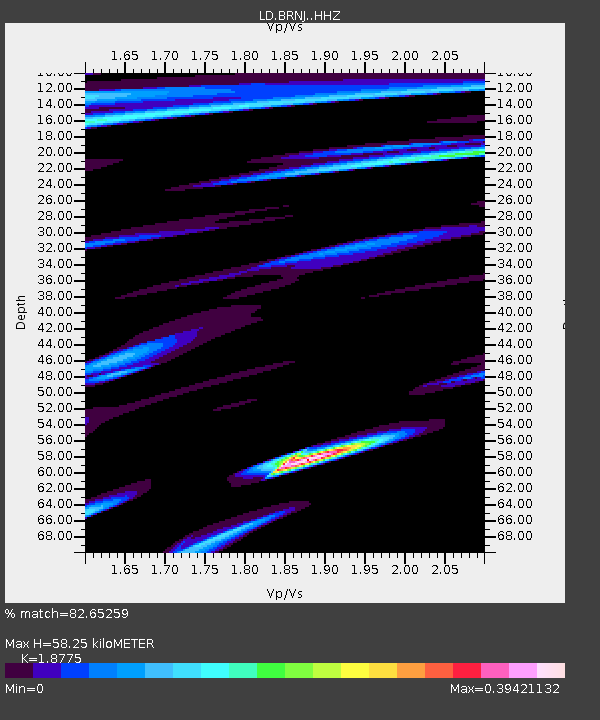
| Estimated Moho Depth: |
58.25 km |
| Estimated Crust Vp/Vs: |
1.88 |
| Assumed Crust Vp: |
6.283 km/s |
| Estimated Crust Vs: |
3.347 km/s |
| Estimated Crust Poisson's Ratio: |
0.30 |
|
| Radial Match: |
82.65259 % |
| Radial Bump: |
335 |
| Transverse Match: |
55.55339 % |
| Transverse Bump: |
400 |
| SOD ConfigId: |
11737051 |
| Insert Time: |
2019-04-25 01:37:00.993 +0000 |
| GWidth: |
2.5 |
| Max Bumps: |
400 |
| Tol: |
0.001 |
|

Signal To Noise
| Channel | StoN | STA | LTA |
| LD:BRNJ: :HHZ:20160711T02:18:08.72001Z | 3.9116855 | 1.6795613E-6 | 4.2937023E-7 |
| LD:BRNJ: :HHN:20160711T02:18:08.72001Z | 2.0553062 | 8.101409E-7 | 3.9417043E-7 |
| LD:BRNJ: :HHE:20160711T02:18:08.72001Z | 0.8093466 | 3.656463E-7 | 4.517796E-7 |
| Arrivals |
| Ps | 8.7 SECOND |
| PpPs | 25 SECOND |
| PsPs/PpSs | 34 SECOND |


