You are here: Home > Network List > LD - Lamont-Doherty Cooperative Seismographic Network Stations List
> Station LUPA Lehigh University, PA > Earthquake Result Viewer
LUPA Lehigh University, PA - Earthquake Result Viewer

| Earthquake location: |
Near Coast Of Ecuador |
| Earthquake latitude/longitude: |
0.6/-79.7 |
| Earthquake time(UTC): |
2016/07/11 (193) 02:11:04 GMT |
| Earthquake Depth: |
19 km |
| Earthquake Magnitude: |
6.3 MWW, 6.3 MWC, 6.3 MWB |
| Earthquake Catalog/Contributor: |
NEIC PDE/NEIC COMCAT |
|
| Network: |
LD Lamont-Doherty Cooperative Seismographic Network |
| Station: |
LUPA Lehigh University, PA |
| Lat/Lon: |
40.60 N/75.37 W |
| Elevation: |
236 m |
|
| Distance: |
40.0 deg |
| Az: |
5.081 deg |
| Baz: |
186.678 deg |
| Ray Param: |
0.07459536 |
| Estimated Moho Depth: |
36.0 km |
| Estimated Crust Vp/Vs: |
1.92 |
| Assumed Crust Vp: |
6.283 km/s |
| Estimated Crust Vs: |
3.277 km/s |
| Estimated Crust Poisson's Ratio: |
0.31 |
|
| Radial Match: |
85.22497 % |
| Radial Bump: |
339 |
| Transverse Match: |
56.784283 % |
| Transverse Bump: |
336 |
| SOD ConfigId: |
11737051 |
| Insert Time: |
2019-04-25 01:37:09.371 +0000 |
| GWidth: |
2.5 |
| Max Bumps: |
400 |
| Tol: |
0.001 |
|
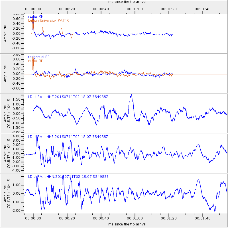
Signal To Noise
| Channel | StoN | STA | LTA |
| LD:LUPA: :HHZ:20160711T02:18:07.384988Z | 4.519297 | 1.7940705E-6 | 3.9697997E-7 |
| LD:LUPA: :HHN:20160711T02:18:07.384988Z | 3.2038324 | 9.1126776E-7 | 2.8443054E-7 |
| LD:LUPA: :HHE:20160711T02:18:07.384988Z | 0.85897565 | 3.2969214E-7 | 3.8382012E-7 |
| Arrivals |
| Ps | 5.6 SECOND |
| PpPs | 16 SECOND |
| PsPs/PpSs | 21 SECOND |


