You are here: Home > Network List > LD - Lamont-Doherty Cooperative Seismographic Network Stations List
> Station WUPA West Chester University of Pennsylvania > Earthquake Result Viewer
WUPA West Chester University of Pennsylvania - Earthquake Result Viewer

| Earthquake location: |
Near Coast Of Ecuador |
| Earthquake latitude/longitude: |
0.6/-79.7 |
| Earthquake time(UTC): |
2016/07/11 (193) 02:11:04 GMT |
| Earthquake Depth: |
19 km |
| Earthquake Magnitude: |
6.3 MWW, 6.3 MWC, 6.3 MWB |
| Earthquake Catalog/Contributor: |
NEIC PDE/NEIC COMCAT |
|
| Network: |
LD Lamont-Doherty Cooperative Seismographic Network |
| Station: |
WUPA West Chester University of Pennsylvania |
| Lat/Lon: |
39.93 N/75.61 W |
| Elevation: |
86 m |
|
| Distance: |
39.4 deg |
| Az: |
4.92 deg |
| Baz: |
186.404 deg |
| Ray Param: |
0.075001955 |
| Estimated Moho Depth: |
66.5 km |
| Estimated Crust Vp/Vs: |
2.07 |
| Assumed Crust Vp: |
6.287 km/s |
| Estimated Crust Vs: |
3.034 km/s |
| Estimated Crust Poisson's Ratio: |
0.35 |
|
| Radial Match: |
84.61346 % |
| Radial Bump: |
278 |
| Transverse Match: |
61.654495 % |
| Transverse Bump: |
343 |
| SOD ConfigId: |
11737051 |
| Insert Time: |
2019-04-25 01:37:21.148 +0000 |
| GWidth: |
2.5 |
| Max Bumps: |
400 |
| Tol: |
0.001 |
|
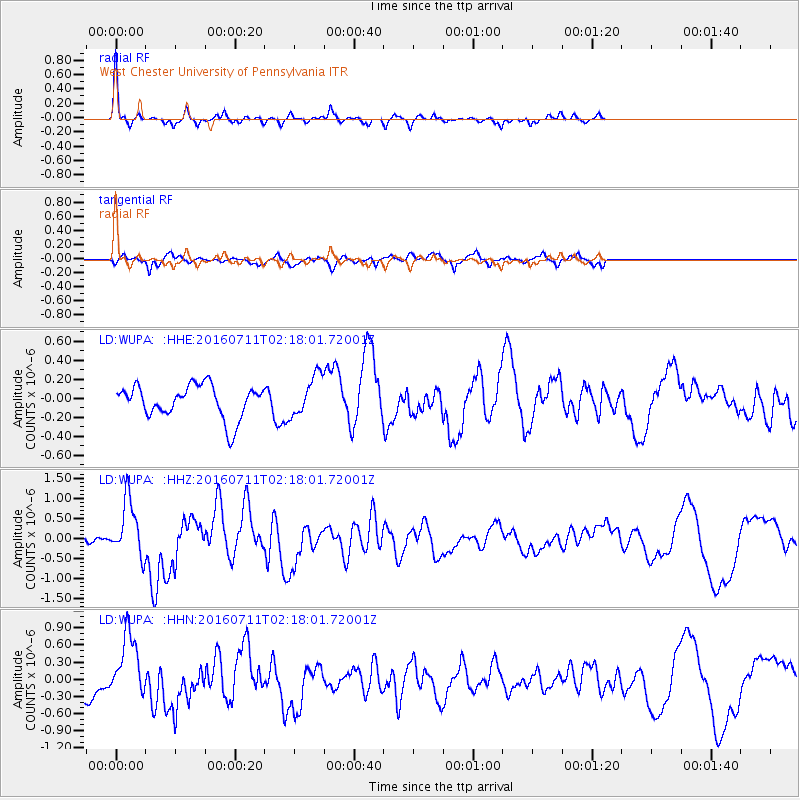
Signal To Noise
| Channel | StoN | STA | LTA |
| LD:WUPA: :HHZ:20160711T02:18:01.72001Z | 3.0517097 | 6.998914E-7 | 2.2934404E-7 |
| LD:WUPA: :HHN:20160711T02:18:01.72001Z | 2.796195 | 5.6072884E-7 | 2.0053281E-7 |
| LD:WUPA: :HHE:20160711T02:18:01.72001Z | 1.2460238 | 2.162415E-7 | 1.7354526E-7 |
| Arrivals |
| Ps | 12 SECOND |
| PpPs | 31 SECOND |
| PsPs/PpSs | 43 SECOND |


