You are here: Home > Network List > US - United States National Seismic Network Stations List
> Station HAWA Hanford, Washington, USA > Earthquake Result Viewer
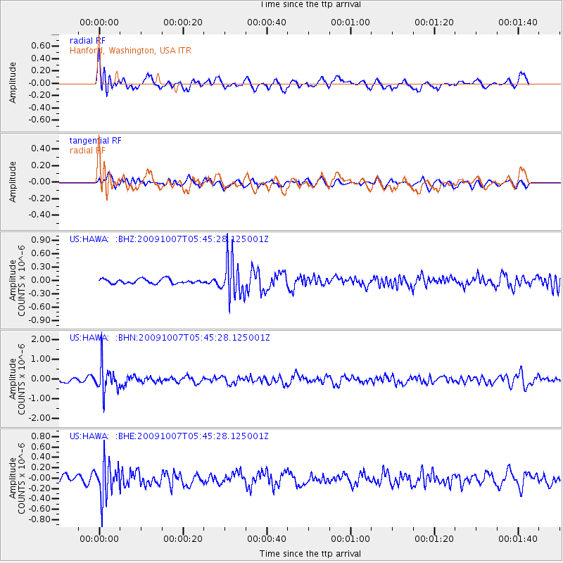
HAWA Hanford, Washington, USA - Earthquake Result Viewer
*The percent match for this event was below the threshold and hence no stack was calculated.
| Earthquake location: |
Rat Islands, Aleutian Islands |
| Earthquake latitude/longitude: |
52.2/178.1 |
| Earthquake time(UTC): |
2009/10/07 (280) 05:38:37 GMT |
| Earthquake Depth: |
138 km |
| Earthquake Magnitude: |
5.6 MB, 5.6 MW, 5.6 MW |
| Earthquake Catalog/Contributor: |
WHDF/NEIC |
|
| Network: |
US United States National Seismic Network |
| Station: |
HAWA Hanford, Washington, USA |
| Lat/Lon: |
46.39 N/119.53 W |
| Elevation: |
364 m |
|
| Distance: |
40.0 deg |
| Az: |
72.604 deg |
| Baz: |
301.856 deg |
| Ray Param: |
$rayparam |
*The percent match for this event was below the threshold and hence was not used in the summary stack. |
|
| Radial Match: |
62.87511 % |
| Radial Bump: |
400 |
| Transverse Match: |
54.178616 % |
| Transverse Bump: |
400 |
| SOD ConfigId: |
2622 |
| Insert Time: |
2010-03-05 05:15:36.654 +0000 |
| GWidth: |
2.5 |
| Max Bumps: |
400 |
| Tol: |
0.001 |
|
Signal To Noise
| Channel | StoN | STA | LTA |
| US:HAWA: :BHN:20091007T05:45:28.125001Z | 4.36643 | 6.862674E-7 | 1.57169E-7 |
| US:HAWA: :BHE:20091007T05:45:28.125001Z | 5.4483685 | 3.267176E-7 | 5.996613E-8 |
| US:HAWA: :BHZ:20091007T05:45:28.125001Z | 8.495869 | 4.2138979E-7 | 4.9599375E-8 |
| Arrivals |
| Ps | |
| PpPs | |
| PsPs/PpSs | |


