You are here: Home > Network List > US - United States National Seismic Network Stations List
> Station HAWA Hanford, Washington, USA > Earthquake Result Viewer
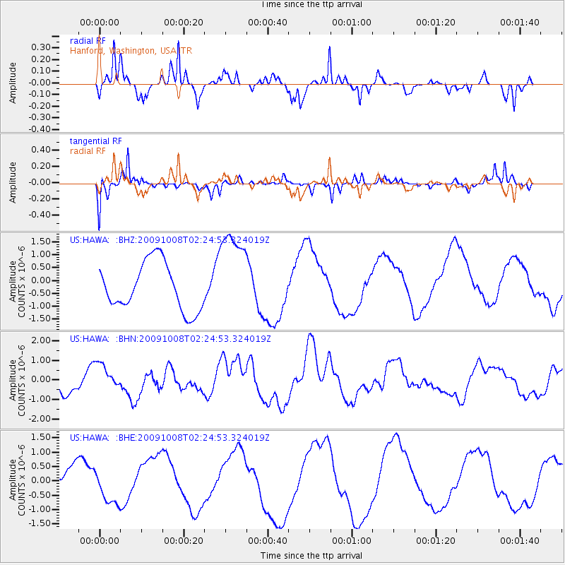
HAWA Hanford, Washington, USA - Earthquake Result Viewer
*The percent match for this event was below the threshold and hence no stack was calculated.
| Earthquake location: |
Santa Cruz Islands |
| Earthquake latitude/longitude: |
-11.7/166.2 |
| Earthquake time(UTC): |
2009/10/08 (281) 02:12:39 GMT |
| Earthquake Depth: |
35 km |
| Earthquake Magnitude: |
5.8 MB, 6.6 MW |
| Earthquake Catalog/Contributor: |
WHDF/NEIC |
|
| Network: |
US United States National Seismic Network |
| Station: |
HAWA Hanford, Washington, USA |
| Lat/Lon: |
46.39 N/119.53 W |
| Elevation: |
364 m |
|
| Distance: |
87.8 deg |
| Az: |
41.819 deg |
| Baz: |
250.69 deg |
| Ray Param: |
$rayparam |
*The percent match for this event was below the threshold and hence was not used in the summary stack. |
|
| Radial Match: |
75.72967 % |
| Radial Bump: |
245 |
| Transverse Match: |
48.77939 % |
| Transverse Bump: |
270 |
| SOD ConfigId: |
2622 |
| Insert Time: |
2010-03-05 05:15:41.349 +0000 |
| GWidth: |
2.5 |
| Max Bumps: |
400 |
| Tol: |
0.001 |
|
Signal To Noise
| Channel | StoN | STA | LTA |
| US:HAWA: :BHN:20091008T02:24:53.324019Z | 1.2696093 | 6.987295E-7 | 5.5034997E-7 |
| US:HAWA: :BHE:20091008T02:24:53.324019Z | 1.3018159 | 6.3526323E-7 | 4.879824E-7 |
| US:HAWA: :BHZ:20091008T02:24:53.324019Z | 1.9369701 | 1.7663518E-6 | 9.119149E-7 |
| Arrivals |
| Ps | |
| PpPs | |
| PsPs/PpSs | |


