You are here: Home > Network List > N4 - Central and EAstern US Network Stations List
> Station I49A Point Hope, MI, USA > Earthquake Result Viewer
I49A Point Hope, MI, USA - Earthquake Result Viewer
| Earthquake location: |
Near Coast Of Ecuador |
| Earthquake latitude/longitude: |
0.6/-79.7 |
| Earthquake time(UTC): |
2016/07/11 (193) 02:11:04 GMT |
| Earthquake Depth: |
19 km |
| Earthquake Magnitude: |
6.3 MWW, 6.3 MWC, 6.3 MWB |
| Earthquake Catalog/Contributor: |
NEIC PDE/NEIC COMCAT |
|
| Network: |
N4 Central and EAstern US Network |
| Station: |
I49A Point Hope, MI, USA |
| Lat/Lon: |
43.94 N/82.82 W |
| Elevation: |
217 m |
|
| Distance: |
43.3 deg |
| Az: |
356.669 deg |
| Baz: |
175.387 deg |
| Ray Param: |
0.0726232 |
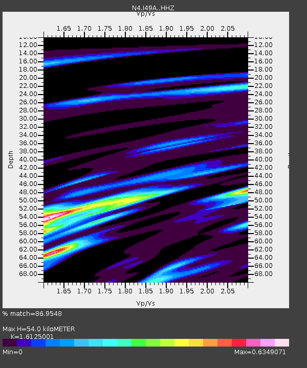
| Estimated Moho Depth: |
54.0 km |
| Estimated Crust Vp/Vs: |
1.61 |
| Assumed Crust Vp: |
6.483 km/s |
| Estimated Crust Vs: |
4.02 km/s |
| Estimated Crust Poisson's Ratio: |
0.19 |
|
| Radial Match: |
86.9548 % |
| Radial Bump: |
255 |
| Transverse Match: |
54.319866 % |
| Transverse Bump: |
398 |
| SOD ConfigId: |
11737051 |
| Insert Time: |
2019-04-25 01:38:01.771 +0000 |
| GWidth: |
2.5 |
| Max Bumps: |
400 |
| Tol: |
0.001 |
|

Signal To Noise
| Channel | StoN | STA | LTA |
| N4:I49A: :HHZ:20160711T02:18:33.910012Z | 7.491769 | 1.8952787E-6 | 2.5298147E-7 |
| N4:I49A: :HHN:20160711T02:18:33.910012Z | 3.3469837 | 8.55017E-7 | 2.5545899E-7 |
| N4:I49A: :HHE:20160711T02:18:33.910012Z | 3.7163064 | 1.1784757E-6 | 3.171094E-7 |
| Arrivals |
| Ps | 5.5 SECOND |
| PpPs | 20 SECOND |
| PsPs/PpSs | 26 SECOND |


