You are here: Home > Network List > N4 - Central and EAstern US Network Stations List
> Station Y60A Bolivia, NC, USA > Earthquake Result Viewer
Y60A Bolivia, NC, USA - Earthquake Result Viewer
| Earthquake location: |
Near Coast Of Ecuador |
| Earthquake latitude/longitude: |
0.6/-79.7 |
| Earthquake time(UTC): |
2016/07/11 (193) 02:11:04 GMT |
| Earthquake Depth: |
19 km |
| Earthquake Magnitude: |
6.3 MWW, 6.3 MWC, 6.3 MWB |
| Earthquake Catalog/Contributor: |
NEIC PDE/NEIC COMCAT |
|
| Network: |
N4 Central and EAstern US Network |
| Station: |
Y60A Bolivia, NC, USA |
| Lat/Lon: |
34.00 N/78.22 W |
| Elevation: |
7.0 m |
|
| Distance: |
33.3 deg |
| Az: |
2.189 deg |
| Baz: |
182.635 deg |
| Ray Param: |
0.078249864 |
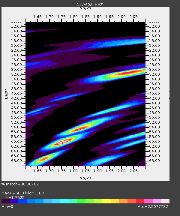
| Estimated Moho Depth: |
60.0 km |
| Estimated Crust Vp/Vs: |
1.75 |
| Assumed Crust Vp: |
6.565 km/s |
| Estimated Crust Vs: |
3.746 km/s |
| Estimated Crust Poisson's Ratio: |
0.26 |
|
| Radial Match: |
80.00782 % |
| Radial Bump: |
400 |
| Transverse Match: |
29.325043 % |
| Transverse Bump: |
394 |
| SOD ConfigId: |
11737051 |
| Insert Time: |
2019-04-25 01:39:21.533 +0000 |
| GWidth: |
2.5 |
| Max Bumps: |
400 |
| Tol: |
0.001 |
|

Signal To Noise
| Channel | StoN | STA | LTA |
| N4:Y60A: :HHZ:20160711T02:17:10.060006Z | 4.5505104 | 2.0727432E-6 | 4.5549686E-7 |
| N4:Y60A: :HHN:20160711T02:17:10.060006Z | 1.7126682 | 1.4179292E-6 | 8.279065E-7 |
| N4:Y60A: :HHE:20160711T02:17:10.060006Z | 0.7767537 | 1.1115806E-6 | 1.4310592E-6 |
| Arrivals |
| Ps | 7.5 SECOND |
| PpPs | 23 SECOND |
| PsPs/PpSs | 31 SECOND |


