You are here: Home > Network List > US - United States National Seismic Network Stations List
> Station HAWA Hanford, Washington, USA > Earthquake Result Viewer
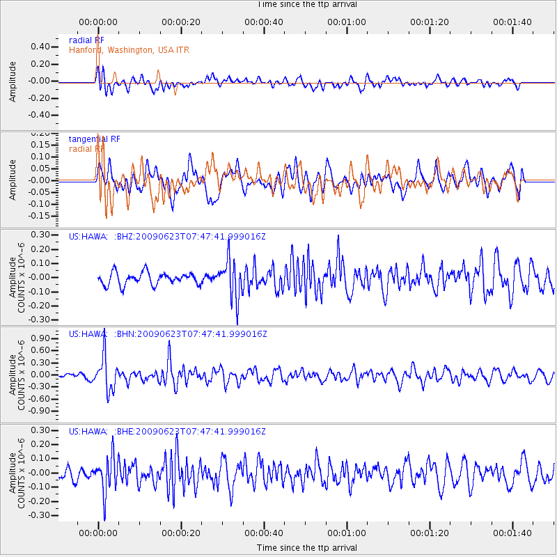
HAWA Hanford, Washington, USA - Earthquake Result Viewer
*The percent match for this event was below the threshold and hence no stack was calculated.
| Earthquake location: |
Near East Coast Of Honshu, Japan |
| Earthquake latitude/longitude: |
38.8/142.4 |
| Earthquake time(UTC): |
2009/06/23 (174) 07:37:17 GMT |
| Earthquake Depth: |
37 km |
| Earthquake Magnitude: |
5.7 MB, 5.0 MS, 5.6 MW, 5.6 MW |
| Earthquake Catalog/Contributor: |
WHDF/NEIC |
|
| Network: |
US United States National Seismic Network |
| Station: |
HAWA Hanford, Washington, USA |
| Lat/Lon: |
46.39 N/119.53 W |
| Elevation: |
364 m |
|
| Distance: |
68.0 deg |
| Az: |
47.663 deg |
| Baz: |
303.495 deg |
| Ray Param: |
$rayparam |
*The percent match for this event was below the threshold and hence was not used in the summary stack. |
|
| Radial Match: |
59.421043 % |
| Radial Bump: |
400 |
| Transverse Match: |
56.46887 % |
| Transverse Bump: |
400 |
| SOD ConfigId: |
2648 |
| Insert Time: |
2010-03-05 05:16:05.829 +0000 |
| GWidth: |
2.5 |
| Max Bumps: |
400 |
| Tol: |
0.001 |
|
Signal To Noise
| Channel | StoN | STA | LTA |
| US:HAWA: :BHN:20090623T07:47:41.999016Z | 4.488003 | 4.2858954E-7 | 9.549672E-8 |
| US:HAWA: :BHE:20090623T07:47:41.999016Z | 2.594986 | 1.2776655E-7 | 4.9235933E-8 |
| US:HAWA: :BHZ:20090623T07:47:41.999016Z | 3.2031121 | 1.3967026E-7 | 4.360455E-8 |
| Arrivals |
| Ps | |
| PpPs | |
| PsPs/PpSs | |


