You are here: Home > Network List > US - United States National Seismic Network Stations List
> Station HAWA Hanford, Washington, USA > Earthquake Result Viewer
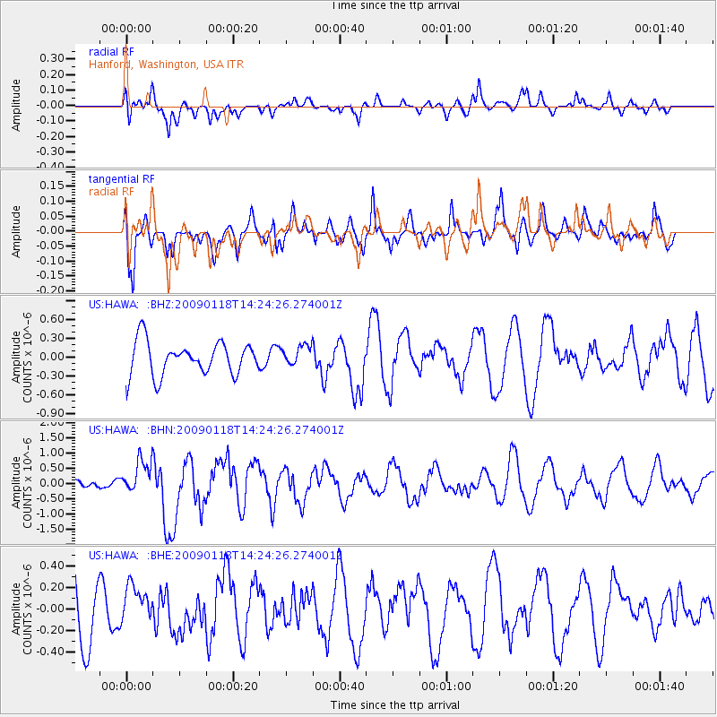
HAWA Hanford, Washington, USA - Earthquake Result Viewer
*The percent match for this event was below the threshold and hence no stack was calculated.
| Earthquake location: |
Kermadec Islands, New Zealand |
| Earthquake latitude/longitude: |
-30.2/-178.0 |
| Earthquake time(UTC): |
2009/01/18 (018) 14:11:48 GMT |
| Earthquake Depth: |
33 km |
| Earthquake Magnitude: |
6.0 MB, 6.1 MS, 6.4 MW, 6.4 MW |
| Earthquake Catalog/Contributor: |
WHDF/NEIC |
|
| Network: |
US United States National Seismic Network |
| Station: |
HAWA Hanford, Washington, USA |
| Lat/Lon: |
46.39 N/119.53 W |
| Elevation: |
364 m |
|
| Distance: |
92.7 deg |
| Az: |
36.178 deg |
| Baz: |
227.591 deg |
| Ray Param: |
$rayparam |
*The percent match for this event was below the threshold and hence was not used in the summary stack. |
|
| Radial Match: |
64.61047 % |
| Radial Bump: |
382 |
| Transverse Match: |
51.557446 % |
| Transverse Bump: |
361 |
| SOD ConfigId: |
2658 |
| Insert Time: |
2010-03-05 05:16:11.501 +0000 |
| GWidth: |
2.5 |
| Max Bumps: |
400 |
| Tol: |
0.001 |
|
Signal To Noise
| Channel | StoN | STA | LTA |
| US:HAWA: :BHN:20090118T14:24:26.274001Z | 3.9344532 | 5.488667E-7 | 1.3950266E-7 |
| US:HAWA: :BHE:20090118T14:24:26.274001Z | 0.55393344 | 1.6658623E-7 | 3.0073332E-7 |
| US:HAWA: :BHZ:20090118T14:24:26.274001Z | 0.6147229 | 1.6188521E-7 | 2.6334666E-7 |
| Arrivals |
| Ps | |
| PpPs | |
| PsPs/PpSs | |


