You are here: Home > Network List > US - United States National Seismic Network Stations List
> Station HAWA Hanford, Washington, USA > Earthquake Result Viewer
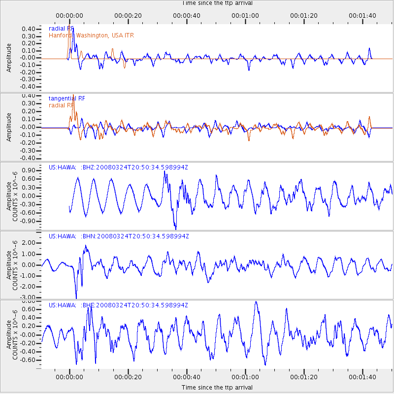
HAWA Hanford, Washington, USA - Earthquake Result Viewer
*The percent match for this event was below the threshold and hence no stack was calculated.
| Earthquake location: |
Chile-Bolivia Border Region |
| Earthquake latitude/longitude: |
-20.0/-69.0 |
| Earthquake time(UTC): |
2008/03/24 (084) 20:39:07 GMT |
| Earthquake Depth: |
120 km |
| Earthquake Magnitude: |
5.7 MB, 6.2 MW, 6.1 MW |
| Earthquake Catalog/Contributor: |
WHDF/NEIC |
|
| Network: |
US United States National Seismic Network |
| Station: |
HAWA Hanford, Washington, USA |
| Lat/Lon: |
46.39 N/119.53 W |
| Elevation: |
364 m |
|
| Distance: |
80.4 deg |
| Az: |
327.162 deg |
| Baz: |
132.559 deg |
| Ray Param: |
$rayparam |
*The percent match for this event was below the threshold and hence was not used in the summary stack. |
|
| Radial Match: |
80.49963 % |
| Radial Bump: |
400 |
| Transverse Match: |
55.4908 % |
| Transverse Bump: |
400 |
| SOD ConfigId: |
2504 |
| Insert Time: |
2010-03-05 05:16:16.691 +0000 |
| GWidth: |
2.5 |
| Max Bumps: |
400 |
| Tol: |
0.001 |
|
Signal To Noise
| Channel | StoN | STA | LTA |
| US:HAWA: :BHN:20080324T20:50:34.598994Z | 1.9245709 | 1.070221E-6 | 5.560829E-7 |
| US:HAWA: :BHE:20080324T20:50:34.598994Z | 0.95157546 | 3.1165226E-7 | 3.2751186E-7 |
| US:HAWA: :BHZ:20080324T20:50:34.598994Z | 1.0633802 | 4.242995E-7 | 3.9901013E-7 |
| Arrivals |
| Ps | |
| PpPs | |
| PsPs/PpSs | |


