You are here: Home > Network List > US - United States National Seismic Network Stations List
> Station HAWA Hanford, Washington, USA > Earthquake Result Viewer
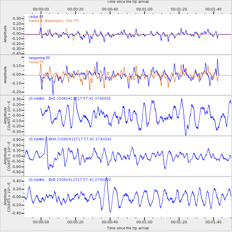
HAWA Hanford, Washington, USA - Earthquake Result Viewer
*The percent match for this event was below the threshold and hence no stack was calculated.
| Earthquake location: |
Loyalty Islands |
| Earthquake latitude/longitude: |
-20.4/168.8 |
| Earthquake time(UTC): |
2008/04/11 (102) 17:45:05 GMT |
| Earthquake Depth: |
35 km |
| Earthquake Magnitude: |
5.7 MB, 5.9 MS, 6.0 MW, 6.0 MW |
| Earthquake Catalog/Contributor: |
WHDF/NEIC |
|
| Network: |
US United States National Seismic Network |
| Station: |
HAWA Hanford, Washington, USA |
| Lat/Lon: |
46.39 N/119.53 W |
| Elevation: |
364 m |
|
| Distance: |
92.6 deg |
| Az: |
41.119 deg |
| Baz: |
243.031 deg |
| Ray Param: |
$rayparam |
*The percent match for this event was below the threshold and hence was not used in the summary stack. |
|
| Radial Match: |
66.36655 % |
| Radial Bump: |
400 |
| Transverse Match: |
71.573364 % |
| Transverse Bump: |
400 |
| SOD ConfigId: |
2504 |
| Insert Time: |
2010-03-05 05:16:18.666 +0000 |
| GWidth: |
2.5 |
| Max Bumps: |
400 |
| Tol: |
0.001 |
|
Signal To Noise
| Channel | StoN | STA | LTA |
| US:HAWA: :BHN:20080411T17:57:42.374009Z | 2.5459492 | 4.8202344E-7 | 1.8932955E-7 |
| US:HAWA: :BHE:20080411T17:57:42.374009Z | 0.7274936 | 7.043016E-8 | 9.681208E-8 |
| US:HAWA: :BHZ:20080411T17:57:42.374009Z | 0.69669205 | 8.686925E-8 | 1.2468816E-7 |
| Arrivals |
| Ps | |
| PpPs | |
| PsPs/PpSs | |


