You are here: Home > Network List > TA - USArray Transportable Network (new EarthScope stations) Stations List
> Station KSCO Kaye Shedlock's, Cheyenne Wells, CO, USA > Earthquake Result Viewer
KSCO Kaye Shedlock's, Cheyenne Wells, CO, USA - Earthquake Result Viewer
| Earthquake location: |
Near Coast Of Ecuador |
| Earthquake latitude/longitude: |
0.6/-79.7 |
| Earthquake time(UTC): |
2016/07/11 (193) 02:11:04 GMT |
| Earthquake Depth: |
19 km |
| Earthquake Magnitude: |
6.3 MWW, 6.3 MWC, 6.3 MWB |
| Earthquake Catalog/Contributor: |
NEIC PDE/NEIC COMCAT |
|
| Network: |
TA USArray Transportable Network (new EarthScope stations) |
| Station: |
KSCO Kaye Shedlock's, Cheyenne Wells, CO, USA |
| Lat/Lon: |
39.01 N/102.63 W |
| Elevation: |
1382 m |
|
| Distance: |
43.7 deg |
| Az: |
333.883 deg |
| Baz: |
145.597 deg |
| Ray Param: |
0.07237685 |
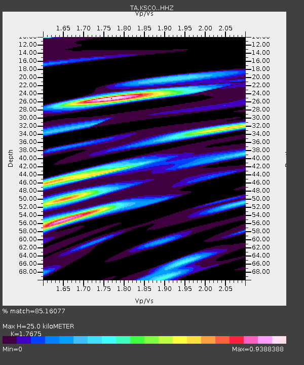
| Estimated Moho Depth: |
25.0 km |
| Estimated Crust Vp/Vs: |
1.77 |
| Assumed Crust Vp: |
6.242 km/s |
| Estimated Crust Vs: |
3.532 km/s |
| Estimated Crust Poisson's Ratio: |
0.26 |
|
| Radial Match: |
85.16077 % |
| Radial Bump: |
361 |
| Transverse Match: |
63.9383 % |
| Transverse Bump: |
400 |
| SOD ConfigId: |
11737051 |
| Insert Time: |
2019-04-25 01:41:50.648 +0000 |
| GWidth: |
2.5 |
| Max Bumps: |
400 |
| Tol: |
0.001 |
|

Signal To Noise
| Channel | StoN | STA | LTA |
| TA:KSCO: :HHZ:20160711T02:18:37.079995Z | 3.8000617 | 9.3747366E-7 | 2.4669959E-7 |
| TA:KSCO: :HHN:20160711T02:18:37.079995Z | 2.3419573 | 4.8741833E-7 | 2.0812436E-7 |
| TA:KSCO: :HHE:20160711T02:18:37.079995Z | 4.4071817 | 1.1104594E-6 | 2.5196587E-7 |
| Arrivals |
| Ps | 3.3 SECOND |
| PpPs | 10 SECOND |
| PsPs/PpSs | 14 SECOND |


