You are here: Home > Network List > TA - USArray Transportable Network (new EarthScope stations) Stations List
> Station M19K Big River Lodge, Big River, AK, USA > Earthquake Result Viewer
M19K Big River Lodge, Big River, AK, USA - Earthquake Result Viewer
| Earthquake location: |
Near Coast Of Ecuador |
| Earthquake latitude/longitude: |
0.6/-79.7 |
| Earthquake time(UTC): |
2016/07/11 (193) 02:11:04 GMT |
| Earthquake Depth: |
19 km |
| Earthquake Magnitude: |
6.3 MWW, 6.3 MWC, 6.3 MWB |
| Earthquake Catalog/Contributor: |
NEIC PDE/NEIC COMCAT |
|
| Network: |
TA USArray Transportable Network (new EarthScope stations) |
| Station: |
M19K Big River Lodge, Big River, AK, USA |
| Lat/Lon: |
61.90 N/154.39 W |
| Elevation: |
521 m |
|
| Distance: |
82.3 deg |
| Az: |
332.561 deg |
| Baz: |
103.267 deg |
| Ray Param: |
0.046933092 |
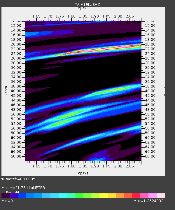
| Estimated Moho Depth: |
21.75 km |
| Estimated Crust Vp/Vs: |
1.94 |
| Assumed Crust Vp: |
6.566 km/s |
| Estimated Crust Vs: |
3.385 km/s |
| Estimated Crust Poisson's Ratio: |
0.32 |
|
| Radial Match: |
83.0895 % |
| Radial Bump: |
400 |
| Transverse Match: |
74.92725 % |
| Transverse Bump: |
400 |
| SOD ConfigId: |
11737051 |
| Insert Time: |
2019-04-25 01:41:55.667 +0000 |
| GWidth: |
2.5 |
| Max Bumps: |
400 |
| Tol: |
0.001 |
|

Signal To Noise
| Channel | StoN | STA | LTA |
| TA:M19K: :BHZ:20160711T02:22:53.525002Z | 6.7156353 | 5.4172426E-7 | 8.0666126E-8 |
| TA:M19K: :BHN:20160711T02:22:53.525002Z | 1.1149256 | 7.724318E-8 | 6.9281015E-8 |
| TA:M19K: :BHE:20160711T02:22:53.525002Z | 2.1463695 | 2.129746E-7 | 9.92255E-8 |
| Arrivals |
| Ps | 3.2 SECOND |
| PpPs | 9.5 SECOND |
| PsPs/PpSs | 13 SECOND |


