You are here: Home > Network List > TA - USArray Transportable Network (new EarthScope stations) Stations List
> Station S22A 4UR Ranch, Creede, CO, USA > Earthquake Result Viewer
S22A 4UR Ranch, Creede, CO, USA - Earthquake Result Viewer
*The percent match for this event was below the threshold and hence no stack was calculated.
| Earthquake location: |
Near Coast Of Ecuador |
| Earthquake latitude/longitude: |
0.6/-79.7 |
| Earthquake time(UTC): |
2016/07/11 (193) 02:11:04 GMT |
| Earthquake Depth: |
19 km |
| Earthquake Magnitude: |
6.3 MWW, 6.3 MWC, 6.3 MWB |
| Earthquake Catalog/Contributor: |
NEIC PDE/NEIC COMCAT |
|
| Network: |
TA USArray Transportable Network (new EarthScope stations) |
| Station: |
S22A 4UR Ranch, Creede, CO, USA |
| Lat/Lon: |
37.75 N/106.83 W |
| Elevation: |
2626 m |
|
| Distance: |
44.7 deg |
| Az: |
329.018 deg |
| Baz: |
139.508 deg |
| Ray Param: |
$rayparam |
*The percent match for this event was below the threshold and hence was not used in the summary stack. |
|
| Radial Match: |
77.39676 % |
| Radial Bump: |
400 |
| Transverse Match: |
64.92479 % |
| Transverse Bump: |
400 |
| SOD ConfigId: |
11737051 |
| Insert Time: |
2019-04-25 01:42:31.405 +0000 |
| GWidth: |
2.5 |
| Max Bumps: |
400 |
| Tol: |
0.001 |
|
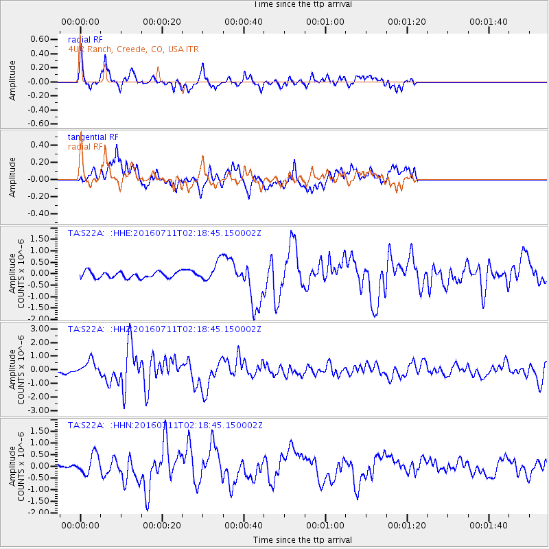
Signal To Noise
| Channel | StoN | STA | LTA |
| TA:S22A: :HHZ:20160711T02:18:45.150002Z | 4.0345945 | 5.3179843E-7 | 1.3180963E-7 |
| TA:S22A: :HHN:20160711T02:18:45.150002Z | 2.677753 | 4.303197E-7 | 1.6070179E-7 |
| TA:S22A: :HHE:20160711T02:18:45.150002Z | 3.161787 | 4.3464297E-7 | 1.3746751E-7 |
| Arrivals |
| Ps | |
| PpPs | |
| PsPs/PpSs | |


