You are here: Home > Network List > US - United States National Seismic Network Stations List
> Station HAWA Hanford, Washington, USA > Earthquake Result Viewer
HAWA Hanford, Washington, USA - Earthquake Result Viewer
*The percent match for this event was below the threshold and hence no stack was calculated.
| Earthquake location: |
Guatemala |
| Earthquake latitude/longitude: |
14.6/-91.2 |
| Earthquake time(UTC): |
2009/05/03 (123) 16:21:47 GMT |
| Earthquake Depth: |
124 km |
| Earthquake Magnitude: |
5.6 MB, 6.2 MW, 6.2 MW |
| Earthquake Catalog/Contributor: |
WHDF/NEIC |
|
| Network: |
US United States National Seismic Network |
| Station: |
HAWA Hanford, Washington, USA |
| Lat/Lon: |
46.39 N/119.53 W |
| Elevation: |
364 m |
|
| Distance: |
39.6 deg |
| Az: |
328.97 deg |
| Baz: |
133.852 deg |
| Ray Param: |
$rayparam |
*The percent match for this event was below the threshold and hence was not used in the summary stack. |
|
| Radial Match: |
68.3957 % |
| Radial Bump: |
400 |
| Transverse Match: |
60.050045 % |
| Transverse Bump: |
400 |
| SOD ConfigId: |
2658 |
| Insert Time: |
2010-03-05 05:16:33.656 +0000 |
| GWidth: |
2.5 |
| Max Bumps: |
400 |
| Tol: |
0.001 |
|
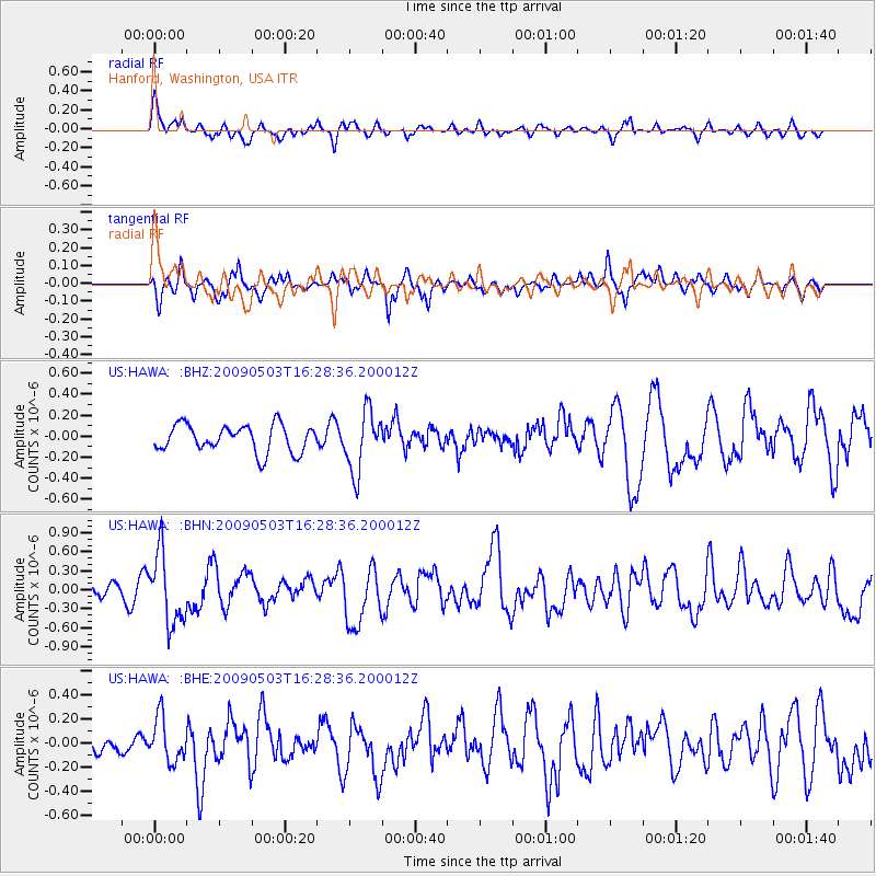
Signal To Noise
| Channel | StoN | STA | LTA |
| US:HAWA: :BHN:20090503T16:28:36.200012Z | 3.3729515 | 5.540099E-7 | 1.6425076E-7 |
| US:HAWA: :BHE:20090503T16:28:36.200012Z | 1.5149696 | 1.8096581E-7 | 1.1945178E-7 |
| US:HAWA: :BHZ:20090503T16:28:36.200012Z | 2.257637 | 2.8939414E-7 | 1.2818452E-7 |
| Arrivals |
| Ps | |
| PpPs | |
| PsPs/PpSs | |


