You are here: Home > Network List > YT07 - POLENET Stations List
> Station WAIS WAIS > Earthquake Result Viewer
WAIS WAIS - Earthquake Result Viewer
| Earthquake location: |
Near Coast Of Ecuador |
| Earthquake latitude/longitude: |
0.6/-79.7 |
| Earthquake time(UTC): |
2016/07/11 (193) 02:11:04 GMT |
| Earthquake Depth: |
19 km |
| Earthquake Magnitude: |
6.3 MWW, 6.3 MWC, 6.3 MWB |
| Earthquake Catalog/Contributor: |
NEIC PDE/NEIC COMCAT |
|
| Network: |
YT POLENET |
| Station: |
WAIS WAIS |
| Lat/Lon: |
79.42 S/111.78 W |
| Elevation: |
1800 m |
|
| Distance: |
81.5 deg |
| Az: |
185.701 deg |
| Baz: |
32.51 deg |
| Ray Param: |
0.047497734 |
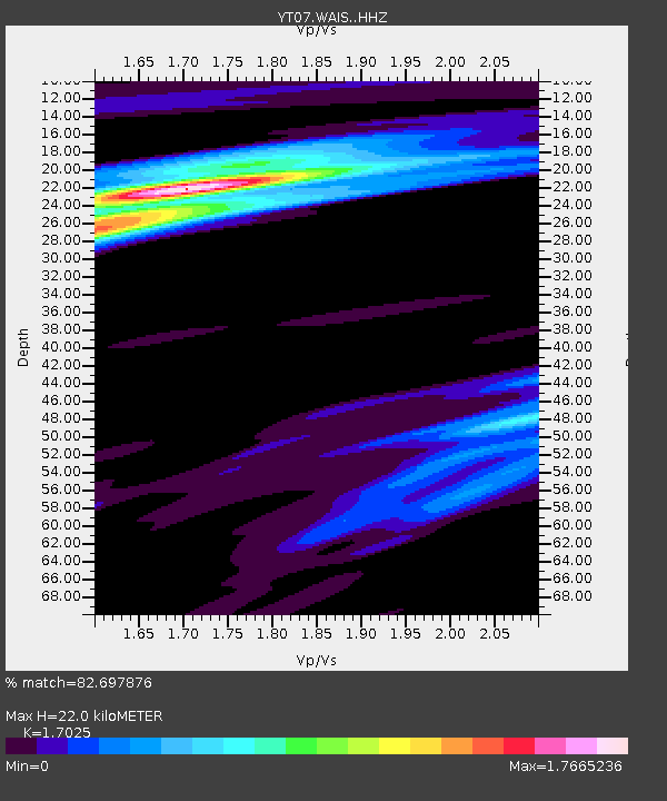
| Estimated Moho Depth: |
22.0 km |
| Estimated Crust Vp/Vs: |
1.70 |
| Assumed Crust Vp: |
5.833 km/s |
| Estimated Crust Vs: |
3.426 km/s |
| Estimated Crust Poisson's Ratio: |
0.24 |
|
| Radial Match: |
82.697876 % |
| Radial Bump: |
340 |
| Transverse Match: |
66.40465 % |
| Transverse Bump: |
400 |
| SOD ConfigId: |
11737051 |
| Insert Time: |
2019-04-25 01:44:56.930 +0000 |
| GWidth: |
2.5 |
| Max Bumps: |
400 |
| Tol: |
0.001 |
|

Signal To Noise
| Channel | StoN | STA | LTA |
| YT:WAIS: :HHZ:20160711T02:22:49.519998Z | 3.6241703 | 4.423085E-7 | 1.2204407E-7 |
| YT:WAIS: :HHN:20160711T02:22:49.519998Z | 1.1250275 | 1.3759963E-7 | 1.2230778E-7 |
| YT:WAIS: :HHE:20160711T02:22:49.519998Z | 1.1176538 | 1.5274371E-7 | 1.366646E-7 |
| Arrivals |
| Ps | 2.7 SECOND |
| PpPs | 10.0 SECOND |
| PsPs/PpSs | 13 SECOND |


