You are here: Home > Network List > US - United States National Seismic Network Stations List
> Station BMO Blue Mountains Array (Baker), Oregon, USA > Earthquake Result Viewer
BMO Blue Mountains Array (Baker), Oregon, USA - Earthquake Result Viewer
| Earthquake location: |
Solomon Islands |
| Earthquake latitude/longitude: |
-9.8/159.5 |
| Earthquake time(UTC): |
2007/08/16 (228) 08:39:27 GMT |
| Earthquake Depth: |
10 km |
| Earthquake Magnitude: |
6.1 MB, 6.7 MS, 6.4 MW |
| Earthquake Catalog/Contributor: |
WHDF/NEIC |
|
| Network: |
US United States National Seismic Network |
| Station: |
BMO Blue Mountains Array (Baker), Oregon, USA |
| Lat/Lon: |
44.85 N/117.31 W |
| Elevation: |
1189 m |
|
| Distance: |
92.1 deg |
| Az: |
44.979 deg |
| Baz: |
258.318 deg |
| Ray Param: |
0.04151027 |
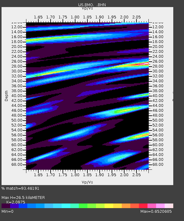
| Estimated Moho Depth: |
26.5 km |
| Estimated Crust Vp/Vs: |
2.10 |
| Assumed Crust Vp: |
6.571 km/s |
| Estimated Crust Vs: |
3.133 km/s |
| Estimated Crust Poisson's Ratio: |
0.35 |
|
| Radial Match: |
93.46191 % |
| Radial Bump: |
400 |
| Transverse Match: |
90.9398 % |
| Transverse Bump: |
400 |
| SOD ConfigId: |
2564 |
| Insert Time: |
2010-03-05 05:16:48.751 +0000 |
| GWidth: |
2.5 |
| Max Bumps: |
400 |
| Tol: |
0.001 |
|

Signal To Noise
| Channel | StoN | STA | LTA |
| US:BMO: :BHN:20070816T08:52:05.302017Z | 3.1479092 | 7.86271E-8 | 2.4977565E-8 |
| US:BMO: :BHE:20070816T08:52:05.302017Z | 2.1140041 | 8.100955E-8 | 3.8320433E-8 |
| US:BMO: :BHZ:20070816T08:52:05.302017Z | 6.023713 | 3.4191328E-7 | 5.6761213E-8 |
| Arrivals |
| Ps | 4.5 SECOND |
| PpPs | 12 SECOND |
| PsPs/PpSs | 17 SECOND |


