You are here: Home > Network List > US - United States National Seismic Network Stations List
> Station BMO Blue Mountains Array (Baker), Oregon, USA > Earthquake Result Viewer
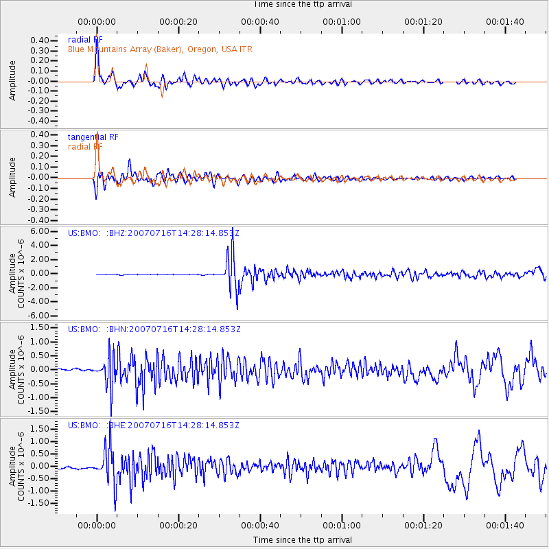
BMO Blue Mountains Array (Baker), Oregon, USA - Earthquake Result Viewer

| Earthquake location: |
Sea Of Japan |
| Earthquake latitude/longitude: |
36.8/134.9 |
| Earthquake time(UTC): |
2007/07/16 (197) 14:17:37 GMT |
| Earthquake Depth: |
350 km |
| Earthquake Magnitude: |
6.2 MB, 6.8 MW, 6.8 MW |
| Earthquake Catalog/Contributor: |
WHDF/NEIC |
|
| Network: |
US United States National Seismic Network |
| Station: |
BMO Blue Mountains Array (Baker), Oregon, USA |
| Lat/Lon: |
44.85 N/117.31 W |
| Elevation: |
1189 m |
|
| Distance: |
75.9 deg |
| Az: |
44.289 deg |
| Baz: |
308.016 deg |
| Ray Param: |
0.050392162 |
| Estimated Moho Depth: |
28.75 km |
| Estimated Crust Vp/Vs: |
1.80 |
| Assumed Crust Vp: |
6.571 km/s |
| Estimated Crust Vs: |
3.661 km/s |
| Estimated Crust Poisson's Ratio: |
0.27 |
|
| Radial Match: |
95.06811 % |
| Radial Bump: |
400 |
| Transverse Match: |
83.73293 % |
| Transverse Bump: |
400 |
| SOD ConfigId: |
2564 |
| Insert Time: |
2010-03-05 05:16:56.146 +0000 |
| GWidth: |
2.5 |
| Max Bumps: |
400 |
| Tol: |
0.001 |
|
Signal To Noise
| Channel | StoN | STA | LTA |
| US:BMO: :BHN:20070716T14:28:14.853Z | 14.121829 | 5.2288465E-7 | 3.7026695E-8 |
| US:BMO: :BHE:20070716T14:28:14.853Z | 11.960883 | 7.4331194E-7 | 6.214524E-8 |
| US:BMO: :BHZ:20070716T14:28:14.853Z | 46.32422 | 2.3728953E-6 | 5.1223644E-8 |
| Arrivals |
| Ps | 3.6 SECOND |
| PpPs | 12 SECOND |
| PsPs/PpSs | 15 SECOND |


