You are here: Home > Network List > TA - USArray Transportable Network (new EarthScope stations) Stations List
> Station O17K Koliganek, Bristol Bay, AK, USA > Earthquake Result Viewer
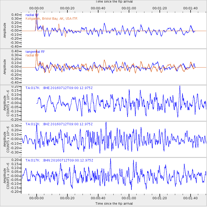
O17K Koliganek, Bristol Bay, AK, USA - Earthquake Result Viewer
*The percent match for this event was below the threshold and hence no stack was calculated.
| Earthquake location: |
Eastern New Guinea Reg., P.N.G. |
| Earthquake latitude/longitude: |
-6.4/147.5 |
| Earthquake time(UTC): |
2016/07/12 (194) 08:48:44 GMT |
| Earthquake Depth: |
43 km |
| Earthquake Magnitude: |
5.6 MWW, 5.6 MWC |
| Earthquake Catalog/Contributor: |
NEIC PDE/NEIC COMCAT |
|
| Network: |
TA USArray Transportable Network (new EarthScope stations) |
| Station: |
O17K Koliganek, Bristol Bay, AK, USA |
| Lat/Lon: |
59.77 N/157.09 W |
| Elevation: |
156 m |
|
| Distance: |
79.1 deg |
| Az: |
25.109 deg |
| Baz: |
236.458 deg |
| Ray Param: |
$rayparam |
*The percent match for this event was below the threshold and hence was not used in the summary stack. |
|
| Radial Match: |
62.51628 % |
| Radial Bump: |
400 |
| Transverse Match: |
50.16548 % |
| Transverse Bump: |
400 |
| SOD ConfigId: |
11737051 |
| Insert Time: |
2019-04-25 01:48:38.762 +0000 |
| GWidth: |
2.5 |
| Max Bumps: |
400 |
| Tol: |
0.001 |
|
Signal To Noise
| Channel | StoN | STA | LTA |
| TA:O17K: :BHZ:20160712T09:00:12.975Z | 2.185912 | 1.308188E-7 | 5.984633E-8 |
| TA:O17K: :BHN:20160712T09:00:12.975Z | 0.63319457 | 3.3180388E-8 | 5.240157E-8 |
| TA:O17K: :BHE:20160712T09:00:12.975Z | 1.5531908 | 7.4119164E-8 | 4.772058E-8 |
| Arrivals |
| Ps | |
| PpPs | |
| PsPs/PpSs | |


