You are here: Home > Network List > US - United States National Seismic Network Stations List
> Station BMO Blue Mountains Array (Baker), Oregon, USA > Earthquake Result Viewer
BMO Blue Mountains Array (Baker), Oregon, USA - Earthquake Result Viewer
| Earthquake location: |
Near Coast Of Guatemala |
| Earthquake latitude/longitude: |
13.8/-90.8 |
| Earthquake time(UTC): |
2007/06/08 (159) 13:32:00 GMT |
| Earthquake Depth: |
48 km |
| Earthquake Magnitude: |
5.5 MB, 5.4 MS, 5.8 MW, 5.8 MW |
| Earthquake Catalog/Contributor: |
WHDF/NEIC |
|
| Network: |
US United States National Seismic Network |
| Station: |
BMO Blue Mountains Array (Baker), Oregon, USA |
| Lat/Lon: |
44.85 N/117.31 W |
| Elevation: |
1189 m |
|
| Distance: |
38.3 deg |
| Az: |
329.121 deg |
| Baz: |
135.506 deg |
| Ray Param: |
0.0755406 |
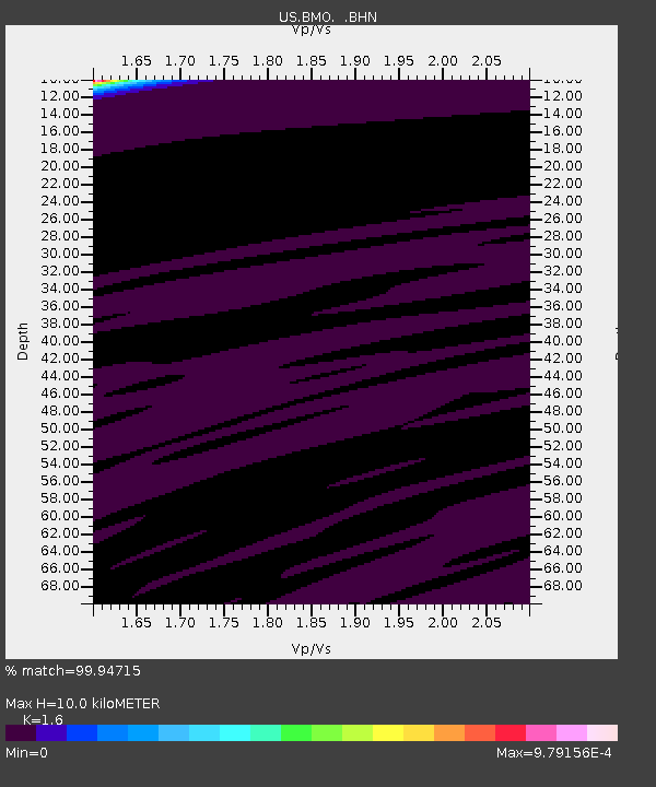
| Estimated Moho Depth: |
10.0 km |
| Estimated Crust Vp/Vs: |
1.60 |
| Assumed Crust Vp: |
6.571 km/s |
| Estimated Crust Vs: |
4.107 km/s |
| Estimated Crust Poisson's Ratio: |
0.18 |
|
| Radial Match: |
99.94715 % |
| Radial Bump: |
7 |
| Transverse Match: |
99.962975 % |
| Transverse Bump: |
8 |
| SOD ConfigId: |
2564 |
| Insert Time: |
2010-03-05 05:17:01.608 +0000 |
| GWidth: |
2.5 |
| Max Bumps: |
400 |
| Tol: |
0.001 |
|
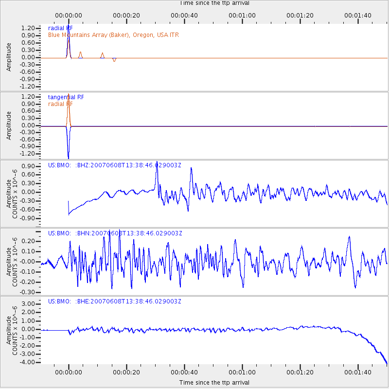
Signal To Noise
| Channel | StoN | STA | LTA |
| US:BMO: :BHN:20070608T13:38:46.029003Z | 3.387118 | 9.815179E-8 | 2.8977963E-8 |
| US:BMO: :BHE:20070608T13:38:46.029003Z | 1.2426616 | 3.7154987E-7 | 2.9899522E-7 |
| US:BMO: :BHZ:20070608T13:38:46.029003Z | 1.9588186 | 4.4497904E-7 | 2.2716705E-7 |
| Arrivals |
| Ps | 1.0 SECOND |
| PpPs | 3.6 SECOND |
| PsPs/PpSs | 4.6 SECOND |


