You are here: Home > Network List > US - United States National Seismic Network Stations List
> Station BMO Blue Mountains Array (Baker), Oregon, USA > Earthquake Result Viewer
BMO Blue Mountains Array (Baker), Oregon, USA - Earthquake Result Viewer
| Earthquake location: |
South Of Mariana Islands |
| Earthquake latitude/longitude: |
10.5/145.7 |
| Earthquake time(UTC): |
2007/09/30 (273) 02:08:30 GMT |
| Earthquake Depth: |
14 km |
| Earthquake Magnitude: |
6.4 MB, 7.1 MS, 6.9 MW, 6.9 MW |
| Earthquake Catalog/Contributor: |
WHDF/NEIC |
|
| Network: |
US United States National Seismic Network |
| Station: |
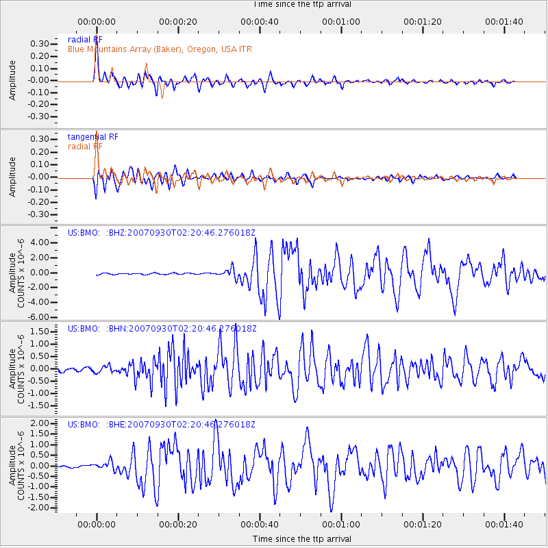
BMO Blue Mountains Array (Baker), Oregon, USA |
| Lat/Lon: |
44.85 N/117.31 W |
| Elevation: |
1189 m |
|
| Distance: |
87.6 deg |
| Az: |
44.966 deg |
| Baz: |
282.262 deg |
| Ray Param: |
0.04319597 |
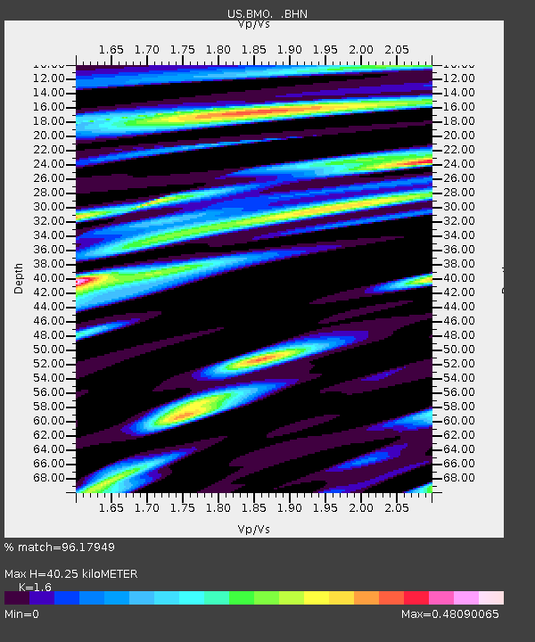
| Estimated Moho Depth: |
40.25 km |
| Estimated Crust Vp/Vs: |
1.60 |
| Assumed Crust Vp: |
6.571 km/s |
| Estimated Crust Vs: |
4.107 km/s |
| Estimated Crust Poisson's Ratio: |
0.18 |
|
| Radial Match: |
96.17949 % |
| Radial Bump: |
400 |
| Transverse Match: |
90.7648 % |
| Transverse Bump: |
400 |
| SOD ConfigId: |
2564 |
| Insert Time: |
2010-03-05 05:17:20.665 +0000 |
| GWidth: |
2.5 |
| Max Bumps: |
400 |
| Tol: |
0.001 |
|
Signal To Noise
| Channel | StoN | STA | LTA |
| US:BMO: :BHN:20070930T02:20:46.276018Z | 1.5788273 | 1.339164E-7 | 8.482017E-8 |
| US:BMO: :BHE:20070930T02:20:46.276018Z | 2.221989 | 1.9670637E-7 | 8.852716E-8 |
| US:BMO: :BHZ:20070930T02:20:46.276018Z | 6.655091 | 6.044383E-7 | 9.082345E-8 |
| Arrivals |
| Ps | 3.8 SECOND |
| PpPs | 16 SECOND |
| PsPs/PpSs | 19 SECOND |


