You are here: Home > Network List > US - United States National Seismic Network Stations List
> Station LONY Lake Ozonia, New York, USA > Earthquake Result Viewer
LONY Lake Ozonia, New York, USA - Earthquake Result Viewer

| Earthquake location: |
Near Coast Of Central Chile |
| Earthquake latitude/longitude: |
-31.6/-71.8 |
| Earthquake time(UTC): |
2015/09/16 (259) 22:54:31 GMT |
| Earthquake Depth: |
12 km |
| Earthquake Magnitude: |
8.3 MWW, 7.9 MI |
| Earthquake Catalog/Contributor: |
NEIC PDE/NEIC COMCAT |
|
| Network: |
US United States National Seismic Network |
| Station: |
LONY Lake Ozonia, New York, USA |
| Lat/Lon: |
44.62 N/74.58 W |
| Elevation: |
440 m |
|
| Distance: |
75.9 deg |
| Az: |
357.916 deg |
| Baz: |
177.509 deg |
| Ray Param: |
0.051364813 |
| Estimated Moho Depth: |
41.5 km |
| Estimated Crust Vp/Vs: |
1.84 |
| Assumed Crust Vp: |
6.419 km/s |
| Estimated Crust Vs: |
3.489 km/s |
| Estimated Crust Poisson's Ratio: |
0.29 |
|
| Radial Match: |
98.66309 % |
| Radial Bump: |
216 |
| Transverse Match: |
97.04075 % |
| Transverse Bump: |
398 |
| SOD ConfigId: |
1156111 |
| Insert Time: |
2015-09-30 23:24:05.512 +0000 |
| GWidth: |
2.5 |
| Max Bumps: |
400 |
| Tol: |
0.001 |
|
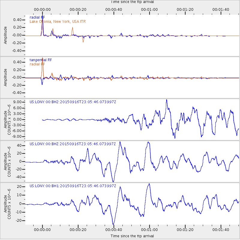
Signal To Noise
| Channel | StoN | STA | LTA |
| US:LONY:00:BHZ:20150916T23:05:46.073997Z | 5.7836385 | 2.325156E-6 | 4.02023E-7 |
| US:LONY:00:BH1:20150916T23:05:46.073997Z | 3.760013 | 8.074031E-7 | 2.1473413E-7 |
| US:LONY:00:BH2:20150916T23:05:46.073997Z | 1.053013 | 2.4725932E-7 | 2.348113E-7 |
| Arrivals |
| Ps | 5.6 SECOND |
| PpPs | 18 SECOND |
| PsPs/PpSs | 23 SECOND |


