You are here: Home > Network List > US - United States National Seismic Network Stations List
> Station MIAR Mount Ida, Arkansas, USA > Earthquake Result Viewer
MIAR Mount Ida, Arkansas, USA - Earthquake Result Viewer
| Earthquake location: |
Near Coast Of Central Chile |
| Earthquake latitude/longitude: |
-31.6/-71.8 |
| Earthquake time(UTC): |
2015/09/16 (259) 22:54:31 GMT |
| Earthquake Depth: |
12 km |
| Earthquake Magnitude: |
8.3 MWW, 7.9 MI |
| Earthquake Catalog/Contributor: |
NEIC PDE/NEIC COMCAT |
|
| Network: |
US United States National Seismic Network |
| Station: |
MIAR Mount Ida, Arkansas, USA |
| Lat/Lon: |
34.55 N/93.58 W |
| Elevation: |
207 m |
|
| Distance: |
68.9 deg |
| Az: |
340.798 deg |
| Baz: |
160.119 deg |
| Ray Param: |
0.055989187 |
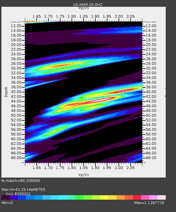
| Estimated Moho Depth: |
43.25 km |
| Estimated Crust Vp/Vs: |
1.92 |
| Assumed Crust Vp: |
6.498 km/s |
| Estimated Crust Vs: |
3.384 km/s |
| Estimated Crust Poisson's Ratio: |
0.31 |
|
| Radial Match: |
98.209885 % |
| Radial Bump: |
400 |
| Transverse Match: |
92.39513 % |
| Transverse Bump: |
400 |
| SOD ConfigId: |
1156111 |
| Insert Time: |
2015-09-30 23:24:15.454 +0000 |
| GWidth: |
2.5 |
| Max Bumps: |
400 |
| Tol: |
0.001 |
|

Signal To Noise
| Channel | StoN | STA | LTA |
| US:MIAR:00:BHZ:20150916T23:05:04.599998Z | 12.179997 | 2.0006783E-6 | 1.6425933E-7 |
| US:MIAR:00:BH1:20150916T23:05:04.599998Z | 12.017912 | 9.810889E-7 | 8.163555E-8 |
| US:MIAR:00:BH2:20150916T23:05:04.599998Z | 5.724955 | 5.006316E-7 | 8.744725E-8 |
| Arrivals |
| Ps | 6.3 SECOND |
| PpPs | 19 SECOND |
| PsPs/PpSs | 25 SECOND |


