You are here: Home > Network List > CI - Caltech Regional Seismic Network Stations List
> Station RRX Rimrock Road, Barstow, CA, USA > Earthquake Result Viewer
RRX Rimrock Road, Barstow, CA, USA - Earthquake Result Viewer
| Earthquake location: |
Santa Cruz Islands Region |
| Earthquake latitude/longitude: |
-11.0/164.5 |
| Earthquake time(UTC): |
2008/07/19 (201) 09:27:01 GMT |
| Earthquake Depth: |
11 km |
| Earthquake Magnitude: |
6.1 MB, 6.4 MS, 6.6 MW, 6.6 MW |
| Earthquake Catalog/Contributor: |
WHDF/NEIC |
|
| Network: |
CI Caltech Regional Seismic Network |
| Station: |
RRX Rimrock Road, Barstow, CA, USA |
| Lat/Lon: |
34.88 N/117.00 W |
| Elevation: |
439 m |
|
| Distance: |
87.0 deg |
| Az: |
53.787 deg |
| Baz: |
254.447 deg |
| Ray Param: |
0.043645516 |
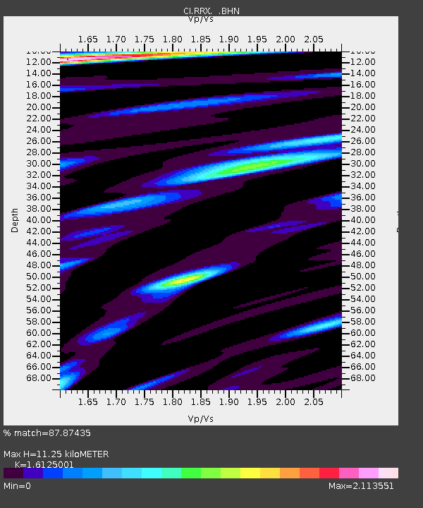
| Estimated Moho Depth: |
11.25 km |
| Estimated Crust Vp/Vs: |
1.61 |
| Assumed Crust Vp: |
6.276 km/s |
| Estimated Crust Vs: |
3.892 km/s |
| Estimated Crust Poisson's Ratio: |
0.19 |
|
| Radial Match: |
87.87435 % |
| Radial Bump: |
400 |
| Transverse Match: |
78.89204 % |
| Transverse Bump: |
400 |
| SOD ConfigId: |
2658 |
| Insert Time: |
2010-02-26 00:34:26.242 +0000 |
| GWidth: |
2.5 |
| Max Bumps: |
400 |
| Tol: |
0.001 |
|
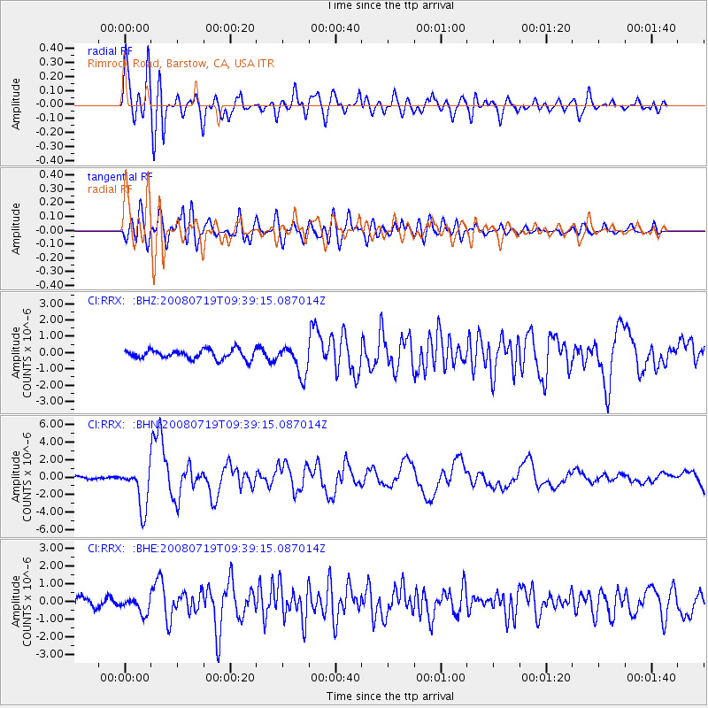
Signal To Noise
| Channel | StoN | STA | LTA |
| CI:RRX: :BHN:20080719T09:39:15.087014Z | 14.771331 | 2.4624724E-6 | 1.6670619E-7 |
| CI:RRX: :BHE:20080719T09:39:15.087014Z | 1.0951161 | 4.4521417E-7 | 4.0654518E-7 |
| CI:RRX: :BHZ:20080719T09:39:15.087014Z | 3.2103145 | 9.2364394E-7 | 2.8771137E-7 |
| Arrivals |
| Ps | 1.1 SECOND |
| PpPs | 4.6 SECOND |
| PsPs/PpSs | 5.7 SECOND |


