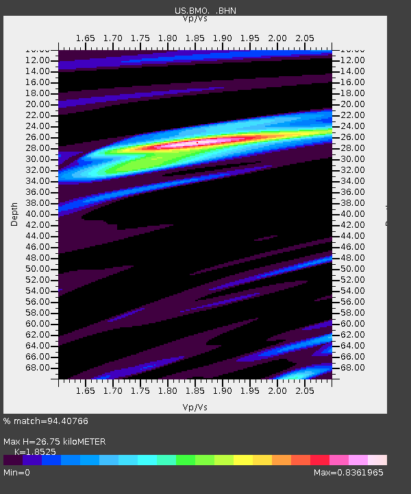
BMO Blue Mountains Array (Baker), Oregon, USA - Earthquake Result Viewer

Earthquake location: Near East Coast Of Honshu, Japan
Earthquake latitude/longitude: 38.1/142.1
Earthquake time(UTC): 2005/12/02 (336) 13:13:09 GMT
Earthquake Depth: 29 km
Earthquake Magnitude: 6.1 MB, 6.3 MS, 6.5 MW, 6.4 MW
Earthquake Catalog/Contributor: WHDF/NEIC
Network: US United States National Seismic Network
Station: BMO Blue Mountains Array (Baker), Oregon, USA
Lat/Lon: 44.85 N/117.31 W
Elevation: 1189 m
Distance: 70.8 deg
Az: 47.768 deg
Baz: 304.782 deg
Ray Param: 0.0546993
Estimated Moho Depth: 26.75 km
Estimated Crust Vp/Vs: 1.85
Assumed Crust Vp: 6.571 km/s
Estimated Crust Vs: 3.547 km/s
Estimated Crust Poisson's Ratio: 0.29
Radial Match: 94.40766 %
Radial Bump: 377
Transverse Match: 88.14174 %
Transverse Bump: 400
SOD ConfigId: 110165
Insert Time: 2010-03-05 05:18:09.157 +0000
GWidth: 2.5
Max Bumps: 400
Tol: 0.001

Signal To Noise

ChannelStoNSTALTA
US:BMO: :BHN:20051202T13:23:52.223003Z1.79475641.6540108E-79.215795E-8
US:BMO: :BHE:20051202T13:23:52.223003Z3.48801852.825486E-78.100547E-8
US:BMO: :BHZ:20051202T13:23:52.223003Z9.0076169.590647E-71.0647264E-7
Arrivals
Ps3.6 SECOND
PpPs11 SECOND
PsPs/PpSs15 SECOND