You are here: Home > Network List > TA - USArray Transportable Network (new EarthScope stations) Stations List
> Station N16K Nishlik Lake, AK, USA > Earthquake Result Viewer
N16K Nishlik Lake, AK, USA - Earthquake Result Viewer
| Earthquake location: |
Kermadec Islands Region |
| Earthquake latitude/longitude: |
-28.2/-176.3 |
| Earthquake time(UTC): |
2016/07/13 (195) 11:56:58 GMT |
| Earthquake Depth: |
17 km |
| Earthquake Magnitude: |
5.7 MB |
| Earthquake Catalog/Contributor: |
NEIC PDE/NEIC COMCAT |
|
| Network: |
TA USArray Transportable Network (new EarthScope stations) |
| Station: |
N16K Nishlik Lake, AK, USA |
| Lat/Lon: |
60.47 N/158.77 W |
| Elevation: |
582 m |
|
| Distance: |
89.5 deg |
| Az: |
8.59 deg |
| Baz: |
195.433 deg |
| Ray Param: |
0.041766487 |
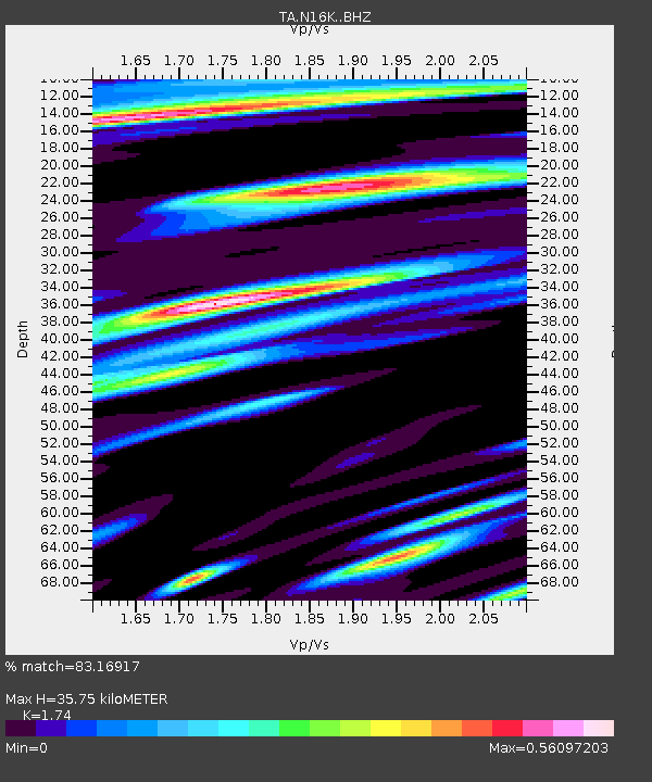
| Estimated Moho Depth: |
35.75 km |
| Estimated Crust Vp/Vs: |
1.74 |
| Assumed Crust Vp: |
6.276 km/s |
| Estimated Crust Vs: |
3.607 km/s |
| Estimated Crust Poisson's Ratio: |
0.25 |
|
| Radial Match: |
83.16917 % |
| Radial Bump: |
400 |
| Transverse Match: |
68.828995 % |
| Transverse Bump: |
400 |
| SOD ConfigId: |
11737051 |
| Insert Time: |
2019-04-25 01:57:10.753 +0000 |
| GWidth: |
2.5 |
| Max Bumps: |
400 |
| Tol: |
0.001 |
|

Signal To Noise
| Channel | StoN | STA | LTA |
| TA:N16K: :BHZ:20160713T12:09:23.25002Z | 8.026084 | 3.5384542E-7 | 4.4086935E-8 |
| TA:N16K: :BHN:20160713T12:09:23.25002Z | 2.7519312 | 1.0563159E-7 | 3.8384535E-8 |
| TA:N16K: :BHE:20160713T12:09:23.25002Z | 1.0029272 | 4.4328743E-8 | 4.4199364E-8 |
| Arrivals |
| Ps | 4.3 SECOND |
| PpPs | 15 SECOND |
| PsPs/PpSs | 20 SECOND |


