You are here: Home > Network List > UW - Pacific Northwest Regional Seismic Network Stations List
> Station MRBL Marblemount, WA, USA > Earthquake Result Viewer
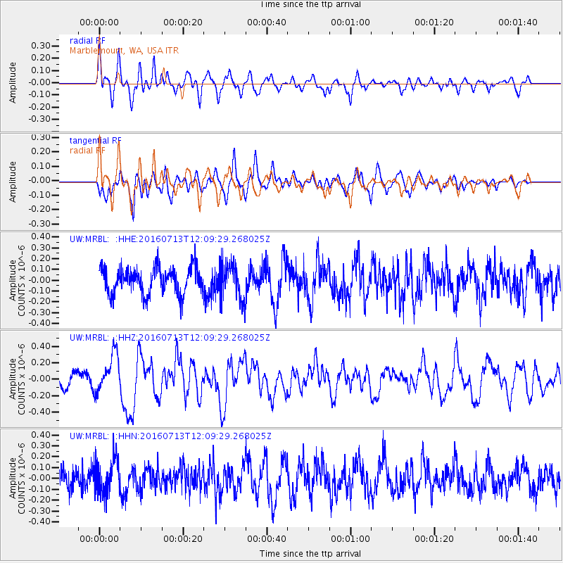
MRBL Marblemount, WA, USA - Earthquake Result Viewer
*The percent match for this event was below the threshold and hence no stack was calculated.
| Earthquake location: |
Kermadec Islands Region |
| Earthquake latitude/longitude: |
-28.2/-176.3 |
| Earthquake time(UTC): |
2016/07/13 (195) 11:56:58 GMT |
| Earthquake Depth: |
17 km |
| Earthquake Magnitude: |
5.7 MB |
| Earthquake Catalog/Contributor: |
NEIC PDE/NEIC COMCAT |
|
| Network: |
UW Pacific Northwest Regional Seismic Network |
| Station: |
MRBL Marblemount, WA, USA |
| Lat/Lon: |
48.52 N/121.48 W |
| Elevation: |
75 m |
|
| Distance: |
90.8 deg |
| Az: |
32.928 deg |
| Baz: |
226.175 deg |
| Ray Param: |
$rayparam |
*The percent match for this event was below the threshold and hence was not used in the summary stack. |
|
| Radial Match: |
62.580196 % |
| Radial Bump: |
400 |
| Transverse Match: |
62.231075 % |
| Transverse Bump: |
400 |
| SOD ConfigId: |
11737051 |
| Insert Time: |
2019-04-25 01:58:03.943 +0000 |
| GWidth: |
2.5 |
| Max Bumps: |
400 |
| Tol: |
0.001 |
|
Signal To Noise
| Channel | StoN | STA | LTA |
| UW:MRBL: :HHZ:20160713T12:09:29.268025Z | 3.0006464 | 2.327728E-7 | 7.757422E-8 |
| UW:MRBL: :HHN:20160713T12:09:29.268025Z | 1.7659787 | 1.5911586E-7 | 9.010066E-8 |
| UW:MRBL: :HHE:20160713T12:09:29.268025Z | 1.3414482 | 1.6224713E-7 | 1.2094924E-7 |
| Arrivals |
| Ps | |
| PpPs | |
| PsPs/PpSs | |


