You are here: Home > Network List > US - United States National Seismic Network Stations List
> Station BMO Blue Mountains Array (Baker), Oregon, USA > Earthquake Result Viewer
BMO Blue Mountains Array (Baker), Oregon, USA - Earthquake Result Viewer
| Earthquake location: |
Southeast Of Honshu, Japan |
| Earthquake latitude/longitude: |
32.8/140.4 |
| Earthquake time(UTC): |
2009/08/12 (224) 22:48:51 GMT |
| Earthquake Depth: |
53 km |
| Earthquake Magnitude: |
6.2 MB, 6.6 MW, 6.6 MW |
| Earthquake Catalog/Contributor: |
WHDF/NEIC |
|
| Network: |
US United States National Seismic Network |
| Station: |
BMO Blue Mountains Array (Baker), Oregon, USA |
| Lat/Lon: |
44.85 N/117.31 W |
| Elevation: |
1189 m |
|
| Distance: |
75.4 deg |
| Az: |
45.898 deg |
| Baz: |
301.785 deg |
| Ray Param: |
0.05157201 |
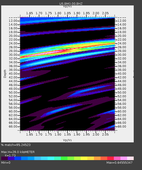
| Estimated Moho Depth: |
29.0 km |
| Estimated Crust Vp/Vs: |
1.73 |
| Assumed Crust Vp: |
6.571 km/s |
| Estimated Crust Vs: |
3.798 km/s |
| Estimated Crust Poisson's Ratio: |
0.25 |
|
| Radial Match: |
95.24523 % |
| Radial Bump: |
400 |
| Transverse Match: |
58.025166 % |
| Transverse Bump: |
400 |
| SOD ConfigId: |
2622 |
| Insert Time: |
2010-03-05 05:18:42.121 +0000 |
| GWidth: |
2.5 |
| Max Bumps: |
400 |
| Tol: |
0.001 |
|

Signal To Noise
| Channel | StoN | STA | LTA |
| US:BMO:00:BHZ:20090812T22:59:58.711016Z | 54.344307 | 3.2833975E-6 | 6.041843E-8 |
| US:BMO:00:BHN:20090812T22:59:58.711016Z | 2.0568652 | 3.8733643E-7 | 1.8831398E-7 |
| US:BMO:00:BHE:20090812T22:59:58.711016Z | 6.0004025 | 1.2658816E-6 | 2.109661E-7 |
| Arrivals |
| Ps | 3.3 SECOND |
| PpPs | 12 SECOND |
| PsPs/PpSs | 15 SECOND |


